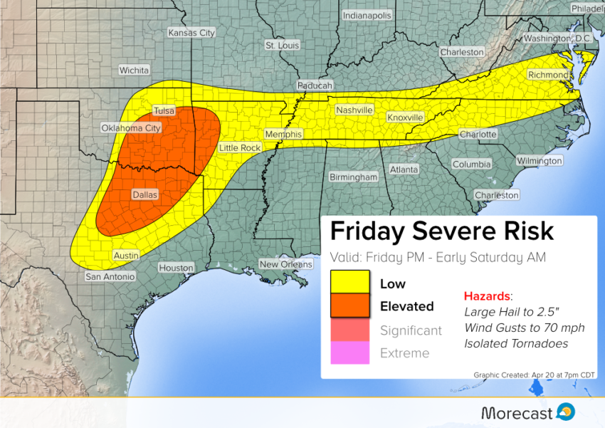
A small but vigorous storm system will roll into the Plains on Friday. Instability building in the afternoon could provide ripe conditions for severe storms. Very large hail will be the most common threat, although the high winds and isolated tornadoes could occur, too.
Morning News
Friday has already seen plenty of flooding across parts of Oklahoma, with many reports coming in of stranded cars.
Severe flooding in north Edmond. Here’s a shot from Val Castor at Danforth & Western. pic.twitter.com/coNBvjh9DG
— Lacey Swope (@LaceySwope) April 21, 2017
Strong winds also brought down power lines across the OKC area, with scattered power outages ongoing as of 10am CDT.
Firefighters: 10 power poles broken along N. May Ave. in Oklahoma City, businesses to shelter in place https://t.co/g13ZU7DBkX #KFORalert pic.twitter.com/KeXiuSabLI
— KFOR (@kfor) April 21, 2017
Forecast Breakdown
Friday morning’s storms could complicate matters by restricting instability available for afternoon severe. However, we’re expecting the morning rains to clear up by the lunchtime, allowing the sun to peek through. In that case, severe storms could bubble up in the mid to late afternoon hours.
The severe risk would continue well into early Saturday morning. Hail to at least 2.5″ will accompany the strongest cells with isolated larger stones possible.
We’ll monitor the situation closely and issue updates as needed on Friday morning via Twitter and Facebook. The scrolling ticker on the MoreCast app will have the latest information as well.