No joke, but wintry weather is in the forecast for parts of the Northeast and Canada leading up to April Fools Day.
The Setup:
A coastal storm will continue to impact the Northeast with rounds of rain and wintry weather into the day Saturday.
Timetable:
Precipitation is currently falling as rain for much of the region, with the exception of some valley locations and higher elevations being cold enough for snow. Heavier precipitation currently to the south will push northward late in the afternoon into Saturday morning. Rain is expected for the coast from New York City southward, however, locations farther north will experience snow and a wintry mix.
Enough warm air aloft will result in a period of freezing rain for interior valleys of Eastern NY and Central New England. Moderate to heavy snow will persists longer for locations further to the north and east.
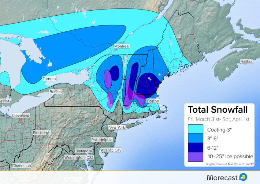
Accumulations of Snow & Ice:
As of this afternoon, snowfall amounts of 3″ had been observed across parts of Northern Massachusetts. An additional coating to 3″ is likely across Eastern NY into Central-Northern New England. 3-6″ may fall across higher elevations of Eastern NY, Litchfield Hills, and locations along and to the north of the Mass Turnpike. 6+” of snow may fall across the high peaks of the Adirondacks, Greens, Whites, Northern Worcester Hills, and much of Southern New Hampshire.
In addition to the snow, enough warm air aloft will result in a period of freezing rain for valley and higher elevations of Central New England and Eastern NY. Freezing rain amounts of between a .10-.25″ may fall.
Due to the nature of the snow and ice accumulation, power outages are likely for areas that receive higher amounts of snow and ice. Please stay tuned to MORECAST for more updates on this upcoming April Fools Day snow threat on Twitter and Facebook.