
The recent warm spell across much of the Northern Plains and Upper Midwest has come to an abrupt end on Thursday. A major winter storm will drop more than a foot of snow with dangerous near-blizzard conditions in spots through Friday. To the south, severe storms are expected on Friday from the Ohio Valley to the eastern Great Lakes.
Wintry Side Of Storm
Low pressure has organized across Colorado early Thursday and will track toward the Great Lakes on Friday.
Watch the evolution of the storm from Morecast’s own in-house weather model.
Snow, heavy at times, will spread eastward from the High Plains of Nebraska to the central and northern Great Lakes through Friday. The heaviest snows will affect portions of southeast Wyoming eastward to Nebraska and into the Upper Midwest. 6-12 inches of snow will be common in the heaviest band. However, local amounts of 12-18 inches could fall in northern Iowa. The heaviest snow will fall south Minneapolis as the metro area lays on the northern fringe of the storm.
Snow will be accompanied by increasing winds Friday and Friday night as the system intensifies, leading to significant drifting and severely reduced visibilities.
Severe Weather
As low pressure strengths across the Plains late Thursday, some locally gusty storms may erupt along and north of I-70 across northern Kansas.
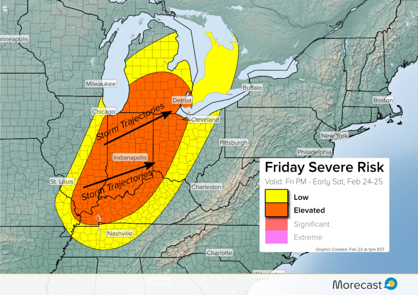
A larger threat for severe weather exists Friday afternoon and evening. Clusters of storms are expected to erupt on Friday afternoon in Illinois. A squall line will move east through the evening and into early Saturday morning, affecting Indianapolis and Detroit among other locales. Destructive winds, locally exceeding 70 mph, will be the most widespread danger. Large hail and a few tornadoes could occur as well.
Morecast meteorologists will be monitoring closely how the situation develops over the next few days and provide updates as needed. Look for the latest information on our Twitter and Facebook feeds, along with the scrolling feature on your Morecast app!