(Updated Monday morning to include wind threat)
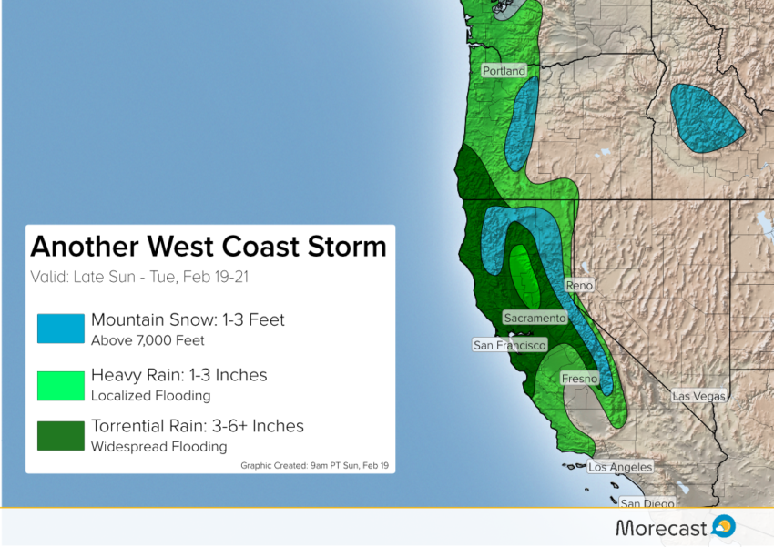
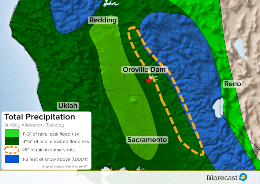
More rain is expected through Tuesday across communities of northern California that have already seen an above average wet season. The additional rain will lead to flash flooding concerns, including in the area around the battered Oroville Dam spillway.
Storm Details
The latest stormy culprit is a series of disturbances that will move into the Pacific Northwest. Each disturbance will bring plentiful moisture and rounds of heavy precipitation from central California to Oregon.
The focus for the heaviest rain is northern California, sparing residents of southern California now in clean-up mode after Friday’s significant storm.
However, this is not good news for residents near and downstream of the still-sensitive Oroville Dam. On Saturday, workers were implementing a plan to clear the dam’s spillway ahead of the expected rain.
Crews are constructing a barge to carry machinery that will dredge debris and sediment that has built up below the flood control spillway. pic.twitter.com/5rNWSp54ni
— CA – DWR (@CA_DWR) February 19, 2017
Morecast meteorologists expect 3-6 inches of rain at the dam site between Sunday and Tuesday. Rain amounts in excess of 6 inches are likely east of the dam at elevations up to 7,000 feet. Flash flooding and mudslides are probable in the area around the dam regardless of how the spillway performs during the upcoming rain event.
Farther north in Oregon, rain will batter the coast and many lower elevations. Portland, which has seen its fair share of wintry weather this season, will remain all rain through the event. Much of the Willamette Valley can expect 1-3 inches of rain to fall by Tuesday afternoon.
Snow
Snow levels across the Sierras will be rather high with the heaviest falling above 7,000 feet. Anywhere from two to five feet of snow is likely in the high country of the Sierras, while much less is expected below 7,000 feet. Impacts from the snow and rain will create road problems for travelers trying to cross the Sierras.
Wind
Rain and snow won’t be the only problems, as strong winds are also expected to howl across much of Northern California Monday night into Tuesday morning. Gusts out of the south-southwest as high as 60 mph will be possible, which could potentially knock down trees and power lines. Larger vehicles such as trucks will also face difficult travel, especially on east-west roads where strong crosswinds could pose a danger.
Widespread Damaging Winds Tonight! Be ready for strong damaging winds. Extended periods of power outages very possible. #CAstorm pic.twitter.com/JgKwr7fwB2
— NWS Sacramento (@NWSSacramento) February 20, 2017
We will keep you informed through the Morecast app as well as our Twitter and Facebook feeds. Stay safe out there!