The same storm system that wreaked havoc in southern California on Friday is emerging from the Desert Southwest today. We’re expecting severe storms to spark late this afternoon into tonight over parts of the Southern Plains. Isolated tornadoes, damaging winds, and large hail will all be threats!
Rich Gulf moisture is being pulled north across Texas today ahead of the approaching system. The atmosphere will become increasingly unstable with storms developing by mid-afternoon in central to northern Texas.
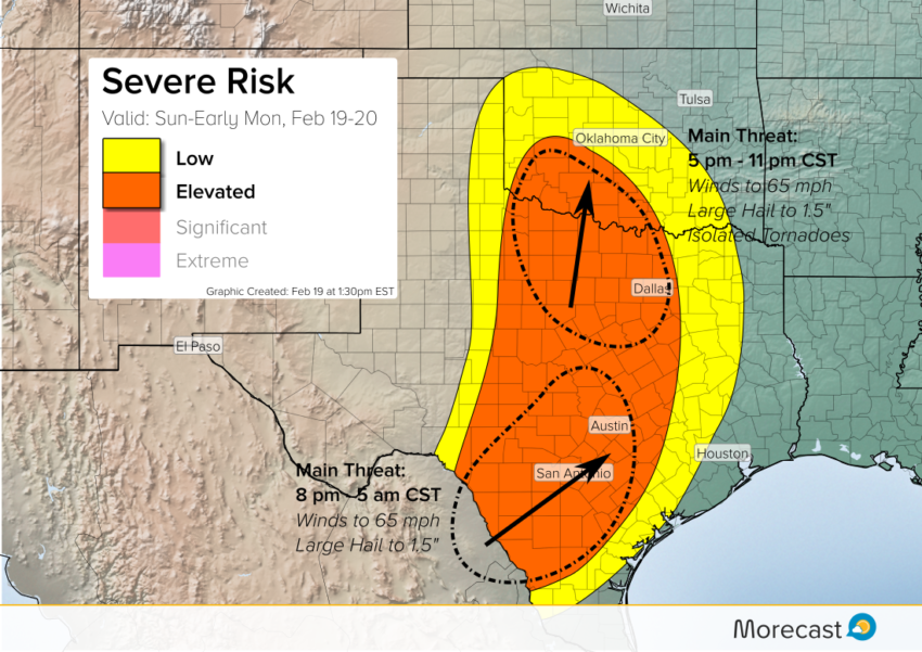
The best chance for severe storms will be this evening. Expect damaging winds to 65 mph, large hail to 1.5″ in diameter, and a couple of tornadoes with the strongest storms. This threat area could include the Dallas-Fort Worth metro area, although a greater risk probably exists to the northwest.
Later in the evening, strong to severe storms developing near or south of the Mexico border could start to cross into south Texas. These storms will tend to move northeast and could impact the Austin-San Antonio area overnight. The tornado risk will be minimal in this area, but damaging wind gusts to 65 mph and large hail to 1.5″ will accompany the hottest cells.
Pay close attention to your local emergency broadcast sources, particularly if an NWS storm watch is issued. Severe storms are particularly dangerous at night due to the lack of visibility. We’ll keep monitoring and issue updates as needed over the Morecast app as well as our Twitter and Facebook pages.