Active weather is going to continue into the early part of the week for the Pac Northwest. Heavy snow will fall in higher elevations with rain and even some snow in the lower elevations.
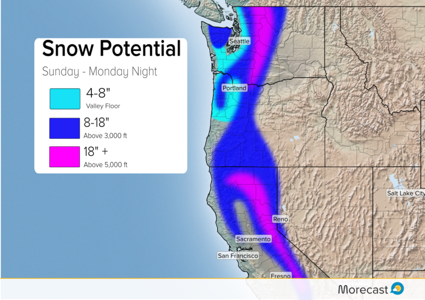
Rain and snow has already overspread the area and will continue through the rest of the weekend into Monday. Snow for most of Sunday will fall mainly above 3,000 feet, the heaviest above 5,000 feet.
Cold air will begin to build in later Sunday and that is going to lower the freezing levels. Freezing levels will reach the valley floor in northern Oregon and southern Washington by Sunday night. This will bring snow to Portland come Sunday night continuing into Monday morning. Snow could be heavy at times Sunday night and this will make for a messy Monday morning commute. Snow totals for Portland are expected to be 4-8″ with most of the snow moving out by late morning Monday.
Seattle will even get in on the snow action Sunday night into Monday. Accumulation will remain much lighter with generally 1-3″. Timing will be unfortunate, though, likely affecting the Monday morning commute.
An active weather pattern is going to remain in place for the west this week. Another system moves into northern California Tuesday and more rain and snow is in the forecast for the Pac Northwest by the end of the week.