A clipper system responsible for snowy conditions Monday will continue east Tuesday into Wednesday.
Intense snow squalls on Monday caused several accidents in Pennsylvania, including a multi-car collision on I-83. Although total snow accumulation was low, the limited visibility and slick roads made driving extremely dangerous.
TRAFFIC UPDATE: All northbound lanes on I-83 have reopened after fatal crash. https://t.co/50MKPkftRn … pic.twitter.com/u2OBUSveXA
— abc27 WHTM (@abc27News) January 30, 2017
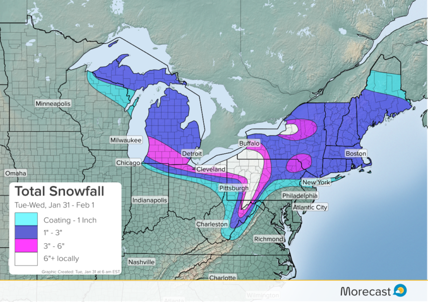
As the Alberta Clipper system moves from the Great Lakes into the Northeast Tuesday, snowy conditions are expected to continue Tuesday into early Wednesday. Lake and mountain enhancement will lead to the heaviest totals downwind of Lakes Erie and Ontario as well as on west-facing slopes of nearby ranges. In these areas six inches or more will accumulate. A larger area including the Poconos will see 3-6 inches. Much of the Great Lakes and Northeast will see a general 1-3 inches of snowfall, including areas of the Urban Corridor north of NYC. The Big Apple itself will see around one inch.
Although it’s not exactly a blockbuster storm, even light accumulations can cause traffic issues, especially around peak commute hours. Exercise caution if you’re out and about today and Wednesday. Keep up with the latest local forecast details and radar imagery using the Morecast app!