Moderate to heavy rain across the Pacific Northwest and British Columbia, with some more localized wintry precipitation, started on Monday and will continue through Wednesday.
Coastal Pac NW
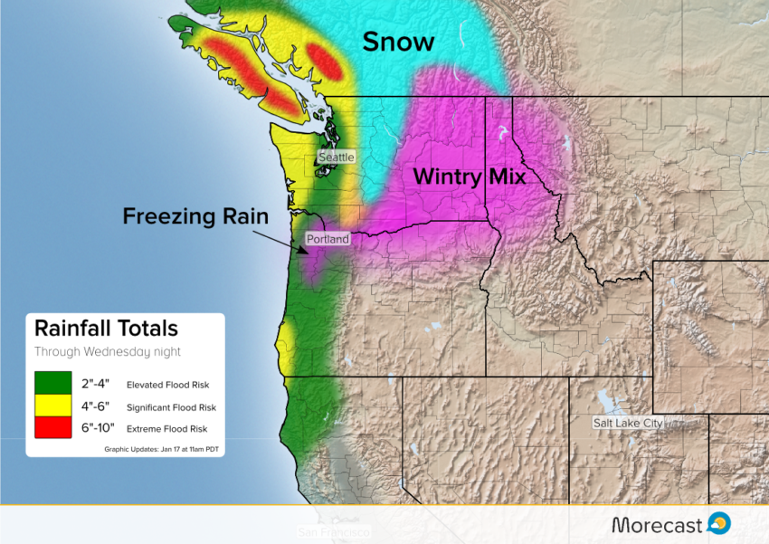
Luckily for the rain hardened cities from Portland to Vancouver, the highest rain totals will be limited to coasts and mountains. Seattle is likely see around 2 inches, benefiting from mountains to the west squeezing out rain before storm clouds reach the city.
Portland itself has been and will continue to be the subject of freezing rain, owing to a quirky local affect. Below freezing air flowing down through the Columbia River Gorge from higher elevations creates perfect conditions for the frozen precipitation. Rain falling through warmer air above begins to freeze upon entering the cold layer nearer the surface, creating the icy conditions when it lands. The National Weather Service has issued warnings for parts of the Portland region through Wednesday.
.@OregonDOT could close I-84 through The Columbia River Gorge today because of wind, freezing rain & 1-2 inches of ice. @KATUNews #LiveOnK2 pic.twitter.com/Y3c8CMYSB1
— Jason Nguyen (@FollowWIN) January 17, 2017
Looking back at rain, the worst on the US side of the border will be over the Olympic Peninsula. Rivers and creeks may become swollen with some road washouts a likelihood. The Cascades just east of Seattle could see up to 6 inches of rain, with snow over the highest peaks.
Canada/Inland Washington
Some wintery mixed precip is expected on the eastern side of the Cascades. We don’t expect huge impacts, but enough to make driving problematic.
North of the border, Vancouver Island and the southern portions of the Coast Range will see large rain amounts similar to the Olympic Peninsula. A more widespread 4-6 inches from the coast into the mountains, including Vancouver, seems probable.
We’ll continue to provide forecast updates on Facebook and Twitter. Open your Morecast app for hyper-local forecast details!