We’ve already seen traffic pile-ups with fatalities as well as power outages, and the worst is yet to come.
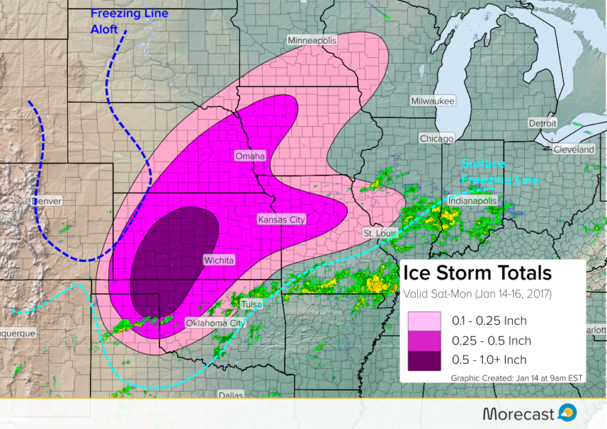
Shallow, frigid air is firmly locked in place across much of the Central Plains north of the light blue dashed line drawn above. However, temps aloft are much warmer, with the subfreezing air confined to the High Plains (navy blue dashed line). The space between these two lines is where to expect a dangerous icy mix. Moisture is streaming north ahead of a strong upper low still off the coast of the Mexican Baja Peninsula. Precipitation has been relatively light thus far but has already caused numerous car accidents due to ice build-up:
1/8″ ice accumulation from freezing rain in El Reno, OK. Roads are a mess. (@ReedTimmerAccu) pic.twitter.com/VST4Rq6Hjm
— Breaking911 Nature (@B911Nature) January 14, 2017
I-40 Western Oklahoma: major back up due to multi truck accident near Weatherford pic.twitter.com/jaYu2WO8Bj
— Damon Lane (@KOCOdamonlane) January 14, 2017
Heavier precipitation, mainly freezing rain, will spread over portions of the Texas Panhandle, western Oklahoma, and Kansas later this afternoon into tonight. By Sunday, the threat will expand to include Missouri, Nebraska, and Iowa. Pockets of heavy freezing rain, perhaps even with lightning, will lead to rapid accumulation of ice in spots. The upper level system will finally sweep out of the region late Monday into early Tuesday
A widespread, damaging ice storm is underway. An area from the northwest Texas Panhandle through northwest Oklahoma to west-central Kansas will see the heaviest icing totals. Totals of 0.5 to one inch will be common with locally higher amounts. Many trees and large branches will come down, leading to widespread power outages that will last for days if not a week or more. Travel will be extremely difficult if not impossible. A larger area, including major cities like Kansas City, Wichita, and Omaha will see ice accumulations of 0.25 to 0.5″. Power outages and hazardous travel conditions will occur in these areas as well.
We’ll continue to provide forecast updates as necessary on Facebook and Twitter. For pinpoint forecast details, consult the Morecast app!