
A major winter storm is unfolding across the Southeast U.S. on Friday. Snow and ice will cause significant travel impacts across areas from Louisiana to Virginia into Saturday.
An area of freezing rain, sleet, and some snow broke out across lower Mississippi Valley on Friday. Ample cold air sagging southward to the Gulf Coast was causing the frozen precipitation to stick on many surfaces.
@spann ice accumulations in Flowood, MS. Currently under a Winter Storm Warning. #mswx pic.twitter.com/gidtH1n5Ki
— Tanner Gough (@gough_tanner) January 6, 2017
Travel along interstates I-20, I-55, and I-59 will be difficult at best through Friday night.
Farther east, the snow and ice will expand into Georgia and the Carolinas.
Forecast:
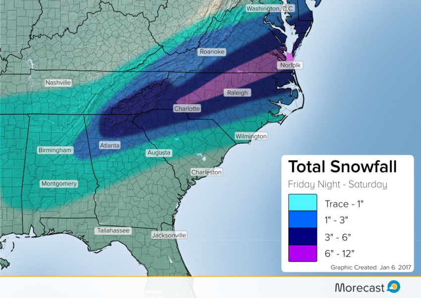
Snow Details:
Snow will spread east from northern Alabama and Georgia Friday afternoon into the Carolinas Friday night. Cities such as Birmingham and Atlanta will start out as a mix of sleet and rain, and then see a gradual transition to all snow later Friday night or early Saturday.
Further east, Charlotte and surrounding areas in west-central North Carolina will see mainly snow, while more coastal cities like Charleston and Wilmington see mostly rain. In between in areas like Raleigh or Norfolk, Virginia, rain and sleet will gradually transition to snow by Saturday morning. This precipitation will continue throughout the day Saturday before tapering off during the overnight hours.
Ice Details:
As colder air from the north penetrates deeper in the Southeast, freezing rain will become a concern from Louisiana to southeast North Carolina. A zone of one to two-tenths of an inch of ice are possible across southern Mississippi and Alabama. A second maxima of freezing rain looks probable across interior South Carolina and southeast North Carolina.
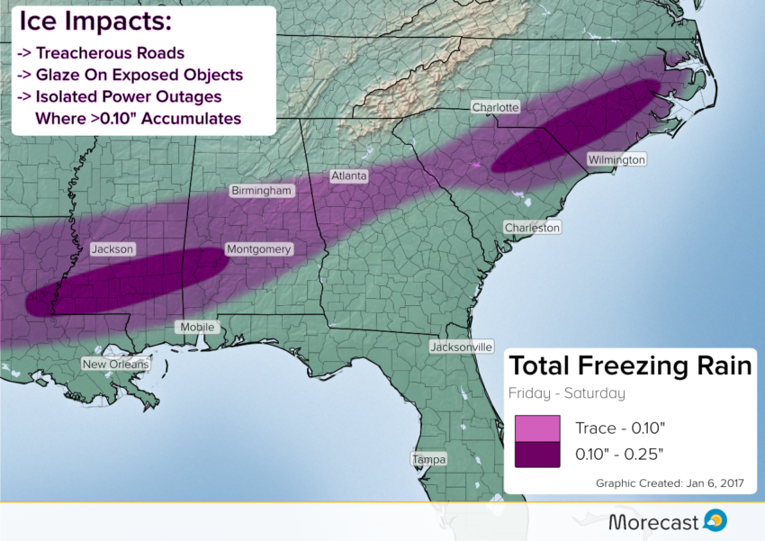
Expect travel delays across much of the Southeast on Friday into Saturday due to the freezing rain potential combined with the snow.
The extent of the cold air driving south into the region will dictate where the heaviest snow and ice sets up, as well as the southern extent of accumulation. If this air stays further north, expect lower accumulations overall. If it plunges further south, higher accumulations will likely be seen in Mississippi, Alabama, Georgia, the Carolinas, and Virginia.
Be sure to monitor this storm as it develops. Residents along a line from Charlotte-Raleigh-Virginia Beach should especially pay attention as movements in the track will change the totals totals. The Morecast team will be on top of the snow bringing you the latest updates, so be sure to follow along on our Facebook and Twitter pages.