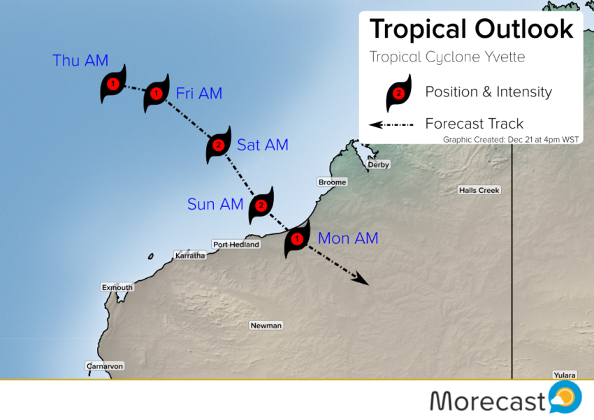
Tropical Cyclone Yvette is meandering about 750 km off the Pilbara coast. It’s gaining strength and is expected to make a move to the southeast later this week. On its current course the cyclone threatens to join a notorious group of storms that made a devastating landfall on Christmas Day!
Easterly wind shear is currently delaying significant intensification despite favorable water temperatures. This shear is expected to relax later in the week, however. This could allow Yvette to intensify and move faster towards the east and southeast. Model guidance does suggest that some intensification will occur, increasing the risk of high winds and flooding rainfall.
A likely landfall area appears to be the stretch of the Kimberley and Pilbara coasts between Port Hedland and Broome known as Eighty-Mile Beach. This is a sparsely populated area, however only a slight deviation would mean a greater threat to cities like Broome or Port Hedland. Although it’s likely to be small, the cyclone will bring dangerous hazards near the landfall point. Damaging wind gusts exceeding 120 kph and torrential rainfall of several hundred millimeters are likely.
Christmas 1974: Cyclone Tracy Wrecks Darwin
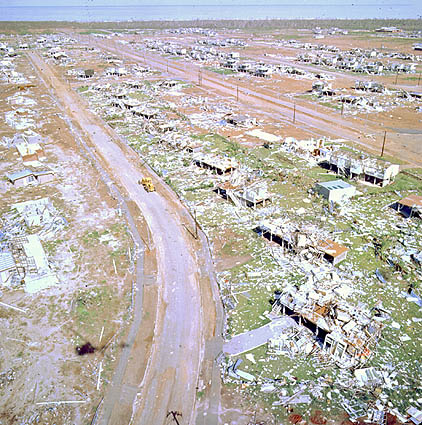
Cyclones have been unwelcome Christmas guests before. Certainly the most infamous landed in late December 1974, Cyclone Tracy, devastating the city of Darwin. Tracy’s claim to fame for the world at large was its size (or lack thereof). It is the most compact cyclone of its incredible power on record. However, for those unlucky enough to have been in range of Tracy’s limited grasp, it was a monster.
For too many people caught up in holiday reverie, Tracy was a total surprise. Some Darwin residents weren’t even aware of the danger until the weather rapidly worsened Christmas Eve night. In the hours just after midnight, winds upwards of 200 kph lashed the city. By daybreak on Christmas morning, conditions were improving, but the horrific damage was done. More than 70% of buildings in Darwin were destroyed, and the cyclone claimed 71 lives.
Fortunately, the chances are extremely low for a repeat tragedy on Christmas 2016. Cyclone Yvette looks like a weaker storm targeting a sparsely-populated area with days of advanced warning instead of mere hours. However, damaging winds as well as storm surge and freshwater flooding can still pose significant dangers. Stay tuned to local news and reliable public sources for the latest forecast information, and heed evacuation orders if they’re given! As always, you can rely on the Morecast app for up-to-date forecast information for your location or holiday destination.