Following the first cold air outbreak of the season, a major winter storm will impact parts of the Plains, Upper Midwest, Great Lakes, and Northeast this weekend into early next week. Heavy snow will begin Saturday night with a mix of snow, rain, and ice working in as the storm tracks further east.
Snow Threat:
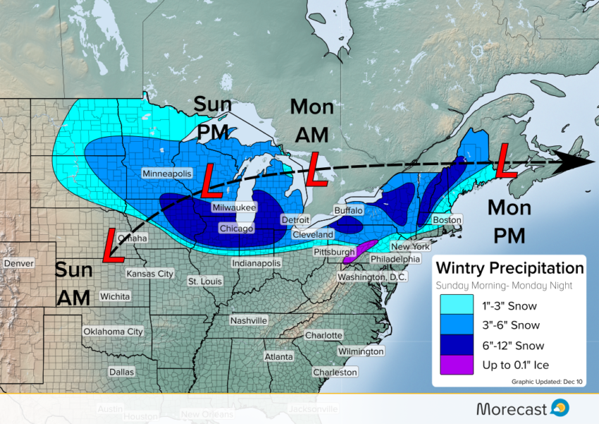
A low pressure system will develop in the Central Plains and intensify as it moves through the Great Lakes. With a cold air mass already in place from the Plains into the Northeast, snow will develop along and ahead of the low. Light snow showers already in place Saturday will intensify and consolidate near the developing low pressure center Sunday morning. Snow will steady through the evening hours for much of the Midwest. A fine like will develop where snow transitions to rain. This line will set up near the I-74 corridor with locations to the north receiving snow. Towns along the rain/snow line will see some of the heaviest snowfall, with 6″-12″ possible. Additionally, windward regions along the Great Lakes will see higher totals. Ongoing lake effect snow showers will transition into more widespread snow, leading to 6″+ in these areas as well.
As the storm tracks further east Sunday night, snow will pick up across western Pennsylvania and New York. The Northeast will not have as sharp of a rain/snow line, and mixed precipitation will work in. Locations north of the I-80 corridor will predominately experience snow. South of this line, rain will mix with snow leading to much lighter accumulations. In the higher terrain of central Pennsylvania, freezing rain may lead the charge before transitioning to snow.
As the storm intensifies on its eastward track, increasing southerly winds will bring warm air out of the South. By the time the storm gets to the I-95 corridor, enough warm air will be pulled north to combat the arctic airmass currently in place. This will lead to mostly rain with some non-accumulating snow mixing in for New York and Philadelphia. Northward to Boston more snow will mix in, but accumulations should be light.
Ice Threat:
Freezing rain is possible for valley locations in Pennsylvania as the surge of warm air ride on top of cold air at the ground. Ice will give way to rain and snow as the storm progresses, but 0.1″ of icing will be possible as precipitation gets underway. Remember to drive with caution in the Allegheny Mountains of Pennsylvania as snow in the highlands may transition to ice in the valleys.
There will likely be widespread travel disruptions on the road and in the air during as this storm plows east. Scattered power outages are possible, especially over the areas of heaviest snow and where ice accretion occurs.The Morecast team will be monitoring the storm and will send updates through our Twitter and Facebook pages. Be sure to check the Morecast app for a hyper-local look at when to expect the flakes to fly!