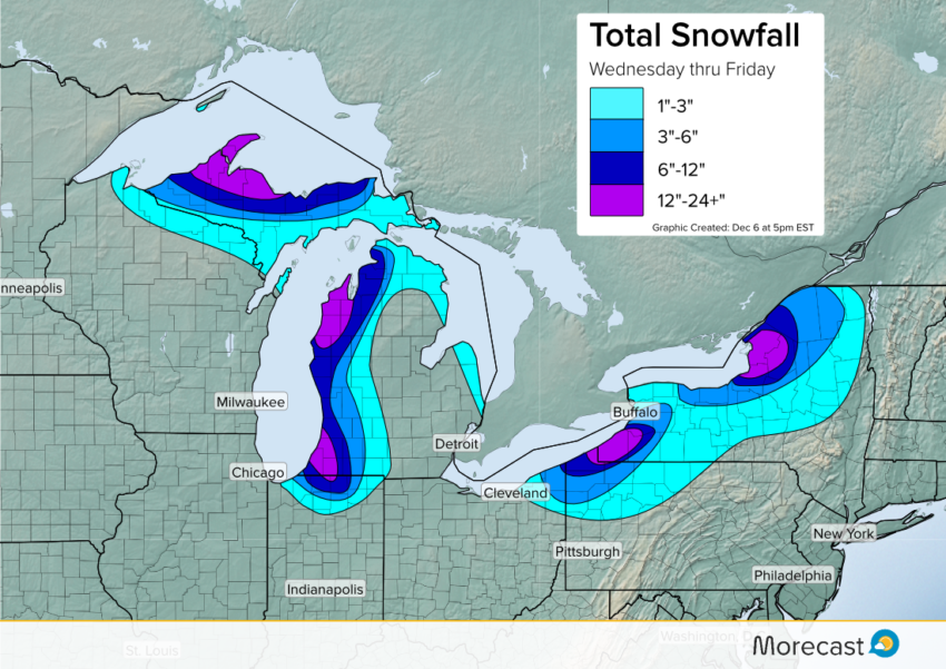
Relatively mild water temperatures between 40°F and 50°F in the Great Lakes will combine with a cold, arctic air mass to crank up the lake effect snow machine starting Wednesday night. And the machine will stay on through Friday afternoon, allowing for some places near the lakes to pick up not inches of snow, but multiple feet.
Lake effect snow is a way of life for those who live in the Great Lakes, especially in the early winter before the waters have frozen over. The mild waters, cold air coming in and wind gusts above 30 mph will lead to heavy snow and whiteout conditions for the second half of the week, making travel difficult to impossible. The weight of snow could also lead to some sporadic power outages, so the snow-hardened folks that live in the snowbelts should prepare before the lake enhanced snows begin to fall Wednesday evening.
While it is possible to know when lake effect snow is likely in an area, it is not possible to forecast exactly where the heaviest bands will set up. The sometimes narrow bands can pound one town, while the next town over sees little to no snow whatsoever. But the places that will see snow in the coming days are likely to see a lot of it, with snowfall rates up to three inches per hour expected in the heaviest bands, which could even lead to some rare thundersnow.
One of the hardest hit places will be the I-90 corridor between Buffalo, NY and Erie, PA. The position of the winds will allow for a good amount of moisture to push inland in these areas, where one to two feet (at least) of snow is possible. The Tug Hill area of Upstate New York is also likely to see significant snow, as the topography enhances the snowfall rates even further. Parts of western Michigan and the Upper Peninsula are also likely to experience some heavy lake effect snow up to at least a foot by Friday evening.