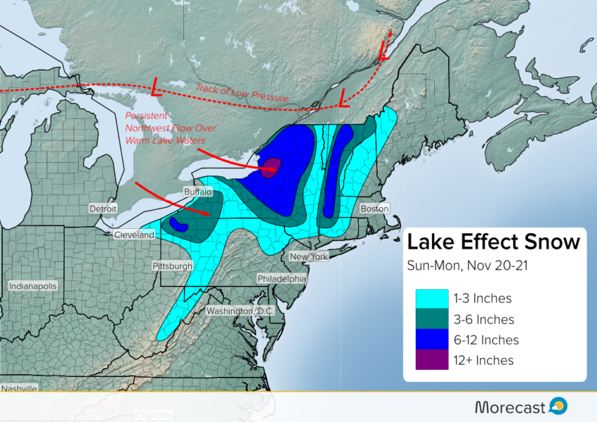
An intense winter storm is raging across Ontario, causing dangerous blizzard conditions and plunging temperatures. Expect this system to move east through Sunday and into early next week, leading to the first big lake effect snow event of the season.
As the low moves east, a strong cold front will sweep across the eastern Great Lakes. Much colder air with persistent northwesterly winds will blow across still-warm lake waters, leading to lake effect snow. Very heavy rates up to to two inches per hour could occur in the heaviest bands. Be cautious when venturing out during these events as heavy snow squalls can severely limit visibility when driving.
#Snow accumulating on the Mass Tpk in the Berkshires. Snow will continue for higher elevations and near the Great Lakes today. #MAwx #NYwx pic.twitter.com/E9lc69GMGU
— Morecast USA (@Morecast_USA) November 20, 2016
Areas especially vulnerable include the Tug Hill plateau east of Lake Ontario and similar higher terrain downwind of Lake Erie. The Tug Hill will probably see over a foot of snow with this event, possibly approaching two feet in spots! Further east, the Green Mountains of Vermont and the Berkshires of Massachusetts could see up to a foot of snow as well in elevations above 1,000 ft. Major cities like Rochester and Syracuse will see plowable amounts of at least three inches, probably exceeding six inches in Syracuse or just north. Buffalo will be spared the brunt of the storm, but the hills just south of the city will get hammered. The snow will subside across the region late Monday or early Tuesday.
We’ll continue to issue updates as needed on Twitter and Facebook. Use the Morecast app for details about timing and to see just how cold temps will get at your locale. Feel free to upload your snow photos!