
We’re only about halfway through autumn, but many are already wondering what the upcoming winter has in store. Will it be dry or will the snow blower be needed regularly? Will it be mild or bone chilling cold? While it’s not possible to answer these questions for any specific winter day this far out (despite what some may claim), it is possible to get an idea on the overall trend expected for the cold season.
Forecast
Forecasters from the National Oceanic and Atmospheric Administration (NOAA) recently released their winter outlook, and here are the main takeaways:
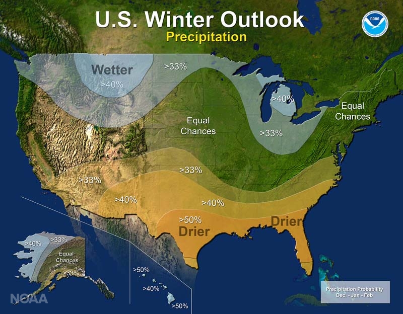
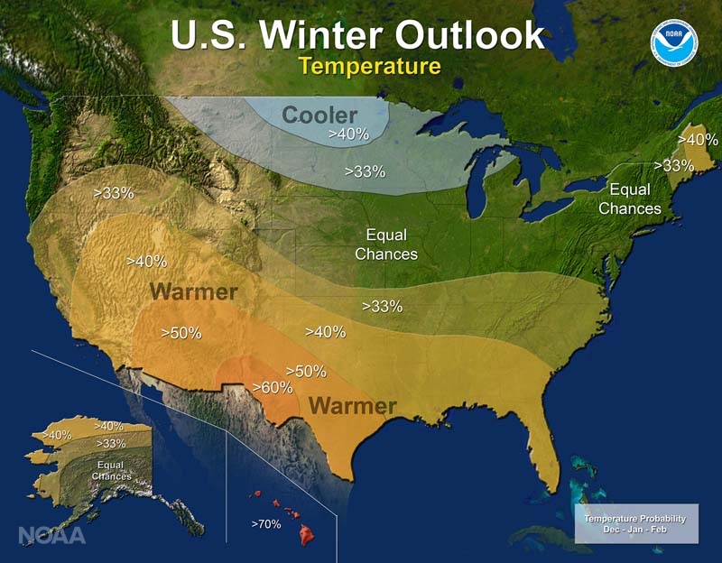
- Odds are higher for below average precipitation and above average temperatures across much of the southern U.S. This is likely to continue and exacerbate drought conditions across the southern half of California and the southeastern U.S.
- Northern New England, especially in Maine, can expect above average temperatures.
- Above average precipitation (mostly snow) is likely for the Northern Rockies and the Great Lakes
- Better chance for below average temperatures across the Northern Plains and Upper Midwest
La Niña
NOAA’s forecasters based much of their winter outlook on the La Niña expected to develop in the Pacific Ocean. La Niña, the counterpart to El Niño, refers to cooler than average waters in the central and eastern equatorial Pacific. These cooler waters impact atmospheric patterns that drive our weather. Even though scientists predict a weak La Niña, forecasters can still look to prior events as a guide for what may happen this winter.
Arctic Oscillation
Another major player in winter weather is the Arctic Oscillation (AO), which has two phases. In a positive phase, the brutally cold air remains locked up around the north pole, leading to moderate temperatures for the U.S. However, when the AO turns negative, the extreme cold drops south, bringing extremely frigid conditions to parts of the country. NOAA’s forecast does not use the AO much for their outlooks, because models can only predict the process out a couple of weeks. But research done by Dr. Judah Cohen of Atmospheric and Environmental Research has shown a possible link between October snowfall in Siberia and the common phase of the AO for the upcoming winter. He recently explained to CBS News that based on above average snowfall this month in Siberia, he expects the AO to frequently be negative this winter, bringing below average temperatures to the central and eastern U.S.
Interpreting NOAA’s Outlook
Back to NOAA’s forecast, it’s important to note their outlook uses probabilities, and should not be taken as absolute. When looking at the central U.S. and much of the Northeast, there is no indication of above or below average temperatures or precipitation. That does not necessarily mean this winter will be normal. Instead, these areas are listed as ‘Equal Chances’. For example, the temperature forecast has New York City in the ‘Equal Chances’ category. This means there is a 33% chance of temperatures being above average, below average, or average this winter. Meanwhile, El Paso, Texas has a 60% chance for a warmer than average winter. That still means there’s a 40% chance the winter will be average or below average temperature-wise in West Texas, but the overall odds favor a warmer one.
It’s also important to remember that the outlooks cover a three month period, and individual extreme events can still occur. Areas expected to be mild most of the winter can still experience cold snaps. Areas expected to be drier than average can still get a big storm that drops a lot of snow. But the outlooks are a useful planning tool of what to expect in the coming months, especially for insurance companies, the retail industry, farmers, and government agencies.