Low pressure tracking from the Great Lakes toward the Northeast coast on Thursday will bring a wintry mix of precipitation through Friday.
A Potpourri of Precipitation:
A period of snow and sleet is possible at the onset of precipitation across the Hudson Valley and other interior Northeast locations.
At least New Paltz looks pretty covered in snow pic.twitter.com/Dl9KxxLAvm
— Lexis Meehan (@lexismeehan) October 27, 2016
As temperatures slowly warm Thursday, the precipitation will change to rain in the lower elevations. However, across the higher terrain, a prolonged period of snow and ice will lead to some accumulation.
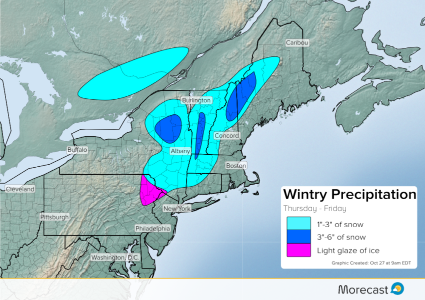
Major roads and interstates such as I-87 and I-90 should remain wet. However, use caution and be prepared for wintry driving conditions across the higher terrain. Slick roads are possible across the Catskills, Adirondacks as well as the Green and the White mountains into Thursday night.
Just rain is expected for the major cities along the I-95 corridor from Washington to Boston
As low pressure moves into the Gulf of Maine on Friday, the precipitation will spread east. Enough warm air will be present across the coastal Northeast as well as the lower terrain of New England for mainly rain.