Saturday Morning Update (11am):
Data from an Air Force Hurricane Hunter flight Saturday morning showed that Matthew was barely holding on to hurricane status, with peak sustained winds weakening to 75 mph. The storm also made its first official landfall in the U.S. Saturday morning, as the eye of the storm moved over McClellanville, South Carolina (located between Charleston and Myrtle Beach). It now looks probable that Matthew could weaken down to a tropical storm at some point Saturday. But even as the winds decrease, the heavy rains continue, and the flood threat remains very high across both North and South Carolina.
Saturday Morning Update (9am):
Hurricane Matthew was downgraded to a category one storm Saturday morning. Centered just off the coast of Charleston, South Carolina, Matthew is still producing sustained winds as high as 85 mph. Even more dangerous, the northern flank of the storm is forcing water from the Atlantic Ocean into coastal towns, while also dumping heavy rains across most of the Carolinas. Several places between Savannah and Charleston have recorded double digit rain totals from Matthew, with the highest amount being at an Army airfield just outside of Savannah, with 17 inches so far.
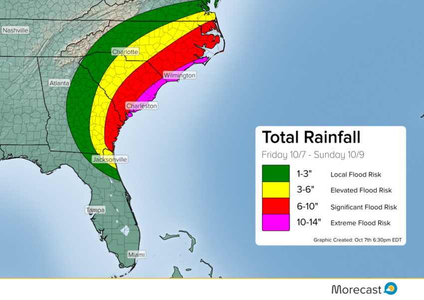
Hurricane Matthew is showing signs of weakening, as it gradually moves northeast along the Carolina coast, but will continue to bring more wind, heavy rain and the threat of storm surge to coastal communities. Once Matthew gets past Wilmington, North Carolina Saturday night, it will finally start to move east, away from shore, while continuing to weaken. But before it does, several places across eastern North Carolina are likely to pick up at least 6-10″ of rain, with higher amounts along the coast. A couple brief, isolated tornadoes will also be possible in North Carolina in some of the northern, outer bands of Matthew.
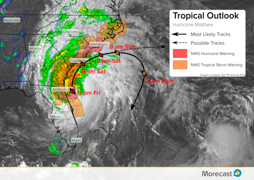
Friday Evening Update (7pm):
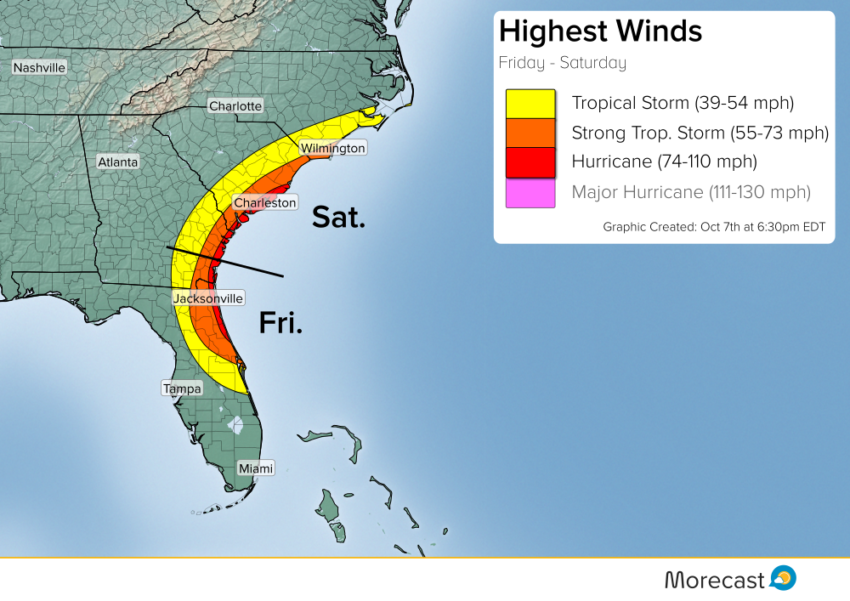
Matthew continues churning through a low shear environment over very warm ocean temperatures. The storm currently remains 40 miles away from Jacksonville, Florida and will likely remain just offshore as it continues up the coast. The Space Coast bore the brunt of the eyewall, however, recording gusts near 110 mph. While the highest winds remain offshore, there is the potential for hurricane strength gusts up to 110 mph along the coast of Florida to South Carolina. Far reaching storm surge has caused massive damage along the northeastern coast of Florida.
Florida:
Though the storm has not made landfall, its effects are being felt from Jacksonville all the way to Savannah, GA. Hurricane conditions are expected for northern Florida’s Atlantic coast today, including:
- Sustained winds exceeding 74 mph. Winds exceeding 100 mph are possible along the Central Coast, with brief gusts to 110 mph.
- Storm surge of at least 5-9 feet along the coast.
- Torrential rainfall of 6-10 inches, locally higher, leading to widespread freshwater flooding.
- Isolated tornadoes. Tropical tornadoes tend to be fast-moving and hard to detect, increasing the danger posed.
Tropical storm conditions are likely for interior Florida and the Gulf Coast. These conditions include:
- Sustained winds exceeding 39 mph, with isolated gusts to hurricane force.
- Heavy rainfall of 2-6 inches leading to isolated flash flooding.
Coastal Georgia and the Carolinas
Matthew is expected to weaken gradually moving forward as shear increases and the cyclone continues to interact with land. However, it will still be a category 2 hurricane as it approaches Georgia and South Carolina. The center will be close enough to produce hurricane force winds, copious rainfall, and a dangerous storm surge along the coast of Georgia and South Carolina tonight into Saturday. Any track closer to or along the coast would mean a higher risk for destruction and threat to life.
After Saturday, steering currents around the cyclone become weaker and the eventual track of Matthew becomes more ambiguous. The latest trends indicate it could make a slow loop off the Southeast coast. While some indications are that the storm will turn to sea, some models loop the storm back, potentially impacting the Bahamas again as a Tropical Storm. We’ll continue to watch Matthew closely through the weekend as long as it remains a potential threat to land.
Follow us on Twitter and Facebook for the latest weather news and forecasts!