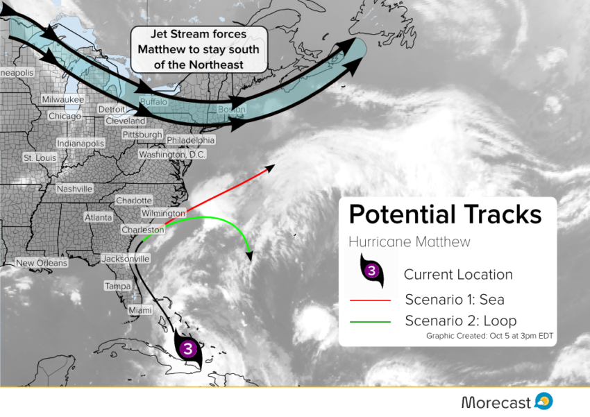
Hurricane Matthew is a category three cyclone packing winds of 120 mph. The storm will likely bring significant impacts to the Southeast coast later this week, but what about the Northeast next week? The Morecast team offers a couple of different possibilities for what to expect long term.
Wednesday October 5th – 3:00 pm (EDT)
Matthew remains a very dangerous hurricane, on track for The Bahamas. Matthew will be roaring past the Bahamas and moves close to the southern coast. Warm water and supportive upper level winds should allow Matthew to remain a powerful hurricane.
Two features thousands of miles apart will guide the movement of Matthew storm through next week. One feature to watch is a very strong ridge of high pressure over the Atlantic. Another is a cold front currently sweeping through the Dakotas.
The storm’s interaction with these features will make the difference between looping in the South or causing some impacts to the Northern Tier. A strong jet stream that is expected to move across the Northeast this weekend helps keep Matthew to the South which will reduce some of the impacts that was initially thought for the Northeast.

Scenario One:
Scenario one assumes the front in the Plains speeds up and the storm gets picked up along the front. This scenario will pull the storm up the Carolina coast an then straight to sea, an ideal situation for Northeasterners with minimal impacts.
Minor impacts north of Virginia:
- Breezy conditions, especially on the beach
- Heavy rainfall
- Occasional high surf/rip currents. Caution advised for swimmers and small watercraft
Scenario Two:
Scenario two assumes a strengthen of the Atlantic high pressure and the slow down of the cold front. As the ridge amplifies Matthew will ride the coast up to the Carolina’s and then cause the forward speed to turn South. This track would bring the least impacts to the East Coast.
Major impacts to the US mainland in the South:
- Intense winds along the coast
- Prolonged flooding rain
- Moderate storm surge
- High surf/rip currents
Minor impacts north of Virginia:
- Occasional high surf/rip currents. Caution advised for swimmers and small watercraft
Models have not been doing a good job picking up what the ridge may do so at this time no scenario or combination thereof can be ruled out. Regardless of the exact track of the storm, some effects may be felt along the Northeast coast. Morecast meteorologists are closely monitoring the situation and will keep you updated as new information becomes available.