The low pressure system that left over 1.5 million South Australians without power is set to move further east today with Tasmania to bear the full brunt of the damaging winds and heavy rainfall.
Morecast Satellite and radar composite. Source: Bureau of Meteorology, Himiwari
SA weather: Woman on the operating table during hospital black-out laughs about her ordeal. https://t.co/Jo95ake6IN pic.twitter.com/1d7dYhgmLd
— ABC News Adelaide (@abcnewsAdelaide) September 29, 2016
Extraordinary scenes at #FishermanBay and #PortBroughton! Never seen anything like it in my life! #SAStorms #SouthAustralia pic.twitter.com/4I3or6UduY
— Sonny Coombs (@SonnyCoombs) September 29, 2016
Jet fuel can’t melt steel beams, but according to some parliamentarians, renewables might just be able to pull it off ??? #SAStorms pic.twitter.com/wPuZb1YqM8
— Larissa Waters (@larissawaters) September 28, 2016
Many South Australians were without power yesterday as severe thunderstorms, destructive winds and heavy rainfall lashed the state. Over 120km/h wind gusts were recorded across South Australia and elevated parts of Victoria with flash flooding causing havoc particularly across Adelaide’s Mt Lofty ranges.
High tides inundating houses at Port Broughton! Keep safe everyone. #SAStorms #SouthAustralia pic.twitter.com/4GLMBwB64p
— Sonny Coombs (@SonnyCoombs) September 29, 2016
Video from farmer Michael Jaeschke of what’s being described as a cyclone hitting Blyth #SAStorms #9News @9NewsAdel pic.twitter.com/25YoPmAVwm
— Jarrad Brevi (@JarradBrevi9) September 28, 2016
However, the severe weather threat is not over yet with the NSW central and Northern Tablelands set to experience strong and gusty winds throughout much of Friday. The outlook is even worse for Tasmania, which is set to bear the full brunt of the storm system with damaging wind gusts and heavy rainfall expected across much of the state until early Friday morning.
Victoria will largely escape most of the severe wind gusts and heavy rainfall although thunderstorms are expected to initiate Friday afternoon with some storms potentially severe.
The low pressure system is possibly one of the most intense in recorded history for South Australia and is somewhat unprecedented for its timing and intensity.
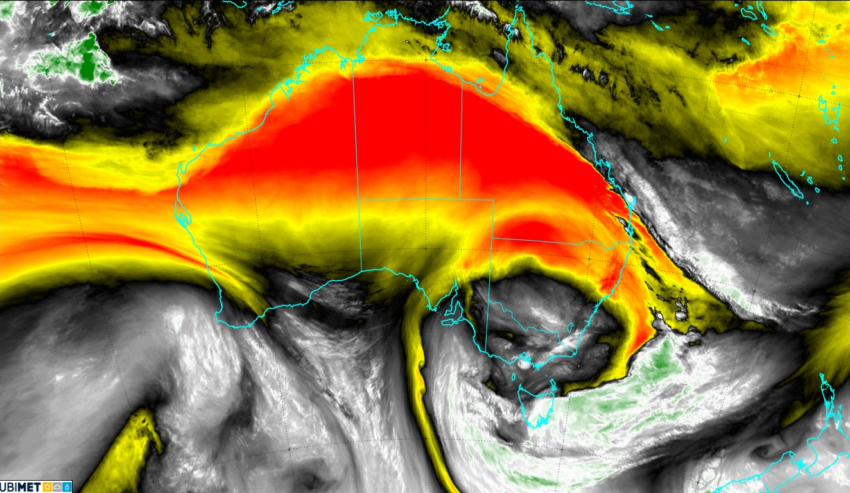
Morecast Water Vapour composite. Source: Bureau of Meteorology, Himiwari
Get the latest weather forecast for your area, download Morecast: http://bit.ly/299O78j