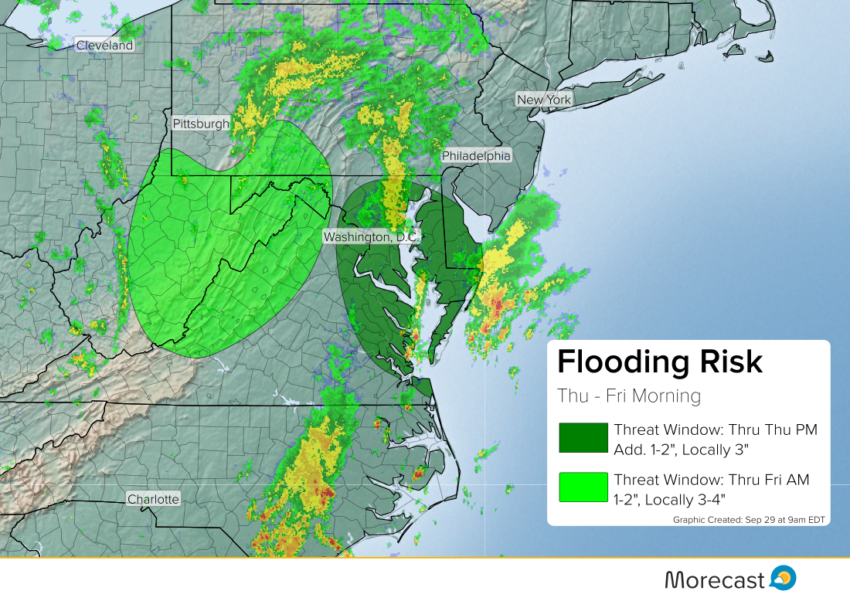
Multiple rounds of slow-moving storms will produce pockets of very heavy rainfall around the Chesapeake Bay today into early this evening. By later today into the overnight hours, a flash flood risk will build for the central Appalachians.
Very heavy rainfall this morning, in some spots up to 4-5 inches, has led to major flooding. Creeks are well out of their banks, leading to road closures:
Claiborne Run out of its banks in Falmouth, VA. Leads into the Rappahannock River. @wusa9 @AllysonRaeWx @hbwx @TenaciousTopper pic.twitter.com/Jsnja9i9pu
— Melissa Nord (@MelissaNordWx) September 29, 2016
The threat for flash flooding will continue in the Chesapeake Bay region through the rest of the day. Additional rainfall of 1-2 inches will be common with a few localized three inch amounts.
Showers and storms will develop a bit further west into the mountains later today into tonight, leading to flash flooding. Amounts of 1-2 inches will be common here, too, with localized higher amounts. Watch for high water over narrow mountain roads with mudslides a possibility!
We’ll issue additional updates as needed over the Morecast app as well as our Twitter and Facebook pages.