Models have remained fairly consistent in recent days on a major storm system impacting southeast Australia, particularly southeast SA, in the next couple of days. Last week we posted on our Facebook page (click here in case you missed it) about this storm’s potential and now it looks sure to be a big one. Below is what Thursday morning’s synoptic map might look like, with a deep low bearing down on southeast SA.
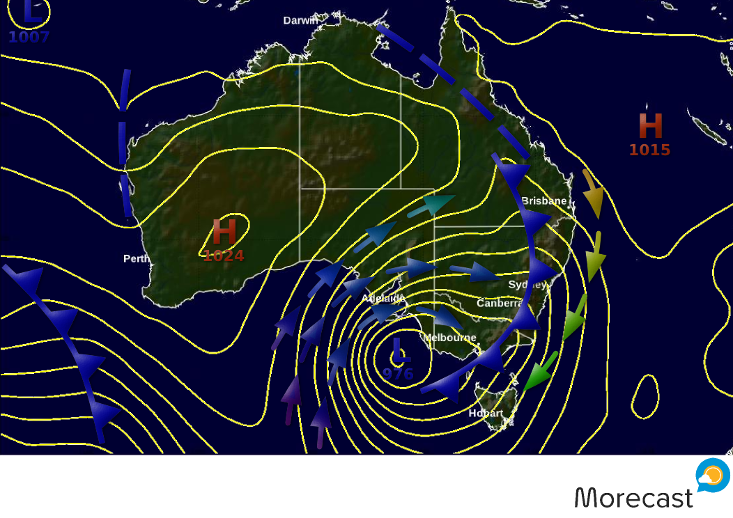
The latest modelling projects a powerful cold front sweeping into SA tomorrow, accompanied by rain and potentially severe thunderstorms. These storms will intensify from mid-morning to early afternoon, particularly from the Eyre Peninsula, across the Yorke Peninsula to the Mid-North and North-East districts and may be accompanied by squalls, large hail, and heavy downpours that lead to flash flooding. Very cold air behind the front will bring rare spring snowfalls to the Lofty Ranges tomorrow night, and even as far north as the northern Flinders Ranges by early Thursday morning.
Connected to the front, a rapidly deepening low, with central pressure dropping below 980 hPa, will dart across the Bight towards southeast SA. Damaging gales to destructive storm-force W-SW’ly wind gusts, displaced from the core, will occur on its northwest flank.
Overnight Wednesday, and into Thursday, fierce winds will blast gulf and peninsula areas, accompanied by squally showers and thunderstorms with possible small hail. Coastal areas will be pounded by large and dangerous waves. Gale force wind gusts will also extend inland to the northeast of the state and western NSW. Heavy rain, especially about the Adelaide Hills and Lofty Ranges, may cause local flooding. The far southeast of SA, being closer to the core of the low, may be spared the worst of the winds, depending on the path it takes.
Through Thursday, the low is likely to cross the lower southeast coast and track across to western Victoria. Further thunderstorms should occur near the low and through western Victoria to southern NSW. Rain will spread across the region with heavy falls likely along northwest facing slopes of the central-to-northeast ranges in Victoria and southeast ranges in NSW. Very moist air wrapping around the eastern flank of the low will likely cause heavy rain across northeast Tasmania with potential for local flooding.
As the coldest air heads east, snowfalls will spread across the alpine regions of Victoria and NSW, spreading to the NSW Central & Northern Tablelands by early Friday, where 5-10cm is possible. In the alpine regions, 30-40cm of fresh snow will provide excellent late season skiing conditions heading into the weekend for the resorts still open.
Get the latest weather forecast for your area, download Morecast: http://bit.ly/299O78j