From wildfire tornadoes to blood rain, weather phenomena has intrigued mankind for centuries. We here at Morecast list our top ten strangest weather phenomena.
10. Undulatus Asperatus Clouds

Wikimedia commons, author: Ave Maria, CC BY-SA 3.0. Source: https://commons.wikimedia.org/w/index.php?curid=6581290
Since the 1950s over 80 separate cloud classifications were created in order to create a standardised cloud identification system. With this comprehensive list, most atmospheric scientists assumed that cloud classification was done and dusted. However, in November 2015 a new cloud type was proposed, Undulatus apparatus.
Described as looking like the surface of the sea on a choppy day, Undulatus Asperatus is thought to form when the wind speed and direction at cloud level causes the cloud to take on an ‘agitated’ wave-like form.
Since first proposed in November 2015, reports around the world are on the rise with the World Meteorological Organisation (WMO) considering the formation to become part of the official classification.
9. Morning Glory

Wikimedia commons, author: Mick Petroff, CC BY-SA 3.0. Source: https://commons.wikimedia.org/wiki/File%3AMorningGloryCloudBurketownFromPlane.jpg
Continuing with the theme of strange cloud formations. The Morning Glory makes it into our list because of its rarity, strange appearance and unclear formation mechanism.
Favourited by glider pilots, the Morning Glory cloud is typically spotted across moist land/sea boundary regions often stretching for many thousands of kilometres. The exact mechanism of the cloud formation is not fully understood, but it is thought to be associated with the interaction of frontal systems crossing very moist air masses and local sea breeze fronts.
Morning Glory clouds are often spotted along coastal regions of north-eastern Australia.
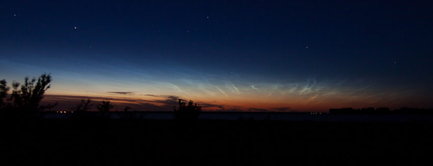
8. Noctilucent Clouds

Wikipedia commons, author: Tunesien2013, CC BY-SA 3.0. Source: https://commons.wikimedia.org/wiki/File%3ANachtleuchtende_Wolken.jpg
Noctilucent clouds are typically seen at twilight and are illuminated by sunlight that is below the horizon (hence its name translating to ‘night shining’ from Latin). They usually form at higher latitudes (between 50 and 70 degrees) and are more common during the summer months.
Noctilucent clouds are comprised of tiny high-altitude ice crystals where the temperature is very cold. Particles high up in the atmosphere such as dust from volcanoes and high altitude aircraft are also thought to contribute to their formation.
7. Fire tornadoes

Wikipedia commons, author: Jrmichae, CC BY-SA 4.0. Source: https://upload.wikimedia.org/wikipedia/commons/2/2d/Pyrocumulus_From_The_Chimney_Fire.JPG
Fire tornadoes or pyro-tornado genesis can occur as a thunderstorm forms over an intense source of heat, such as the heat generated from a wildfire.
In 2003, a severe bushfire in Australia’s capital, Canberra caused a thunderstorm to develop with a confirmed F2 (181-252km/h winds) tornado embedded in the wildfire (see below). The result was devastating and similar events around the world have sparked further research into the field of Pyro-convective events.
6. Volcanic lightning

Wikimedia commons, author: Terje Sørgjerd, CC BY-SA 3.0. Source: https://commons.wikimedia.org/wiki/File%3AEyjafjallaj%C3%B6kull_by_Terje_S%C3%B8rgjerd.jpg.
The intense mixture of heat and ash particles from a volcanic eruption often produces a spectacular lightning show.
Volcanic lightning is caused by the static electricity of ash particles rubbing against each other and the interaction of this ash with ice crystals higher up in the atmosphere. The presence of volcanic ash and high altitude particles causes the lightning to change colour as the wavelength of light reaching our eyes is altered.
5. Blood rain

Wikimedia commons, author: Merbabu, CC BY-SA 3.0. Source: https://commons.wikimedia.org/wiki/File%3ASydney_Dust_Storm_6am.JPG
Reports of blood rain extend back as far 700BC with the philosopher Homer, describing the phenomena as a warning from the god Zeus. Today, reports of blood rain still occur across multiple locations worldwide with modern day meteorology providing a comprehensive explanation.
Blood rain forms when dust from arid environments such as the Sahara desert (Saharan dust) mixes with cloud water droplets to form rustic-coloured rain.
4. St Elmo’s Fire

Wikimedia commons, author: (public domain), CC BY-SA 3.0. Source: https://commons.wikimedia.org/wiki/File%3AElmo’s_fire.jpg
Historically considered as a sailor’s ‘good omen’, St. Elmo’s Fire is a phenomenon that causes sharp objects to illuminate in bright blue/violet glow.
St. Elmo’s fire occurs in the presence of a strong electric field which causes molecules in the air to temporary conduct electricity through a process known as ionisation. This effect typically occurs near thunderstorm activity where there is a large potential difference between the earth or other storm clouds.
The phenomena can also be seen as an aircraft flies through a storm cloud (see below).
3. Green Ray

Wikimedia commons, author: Brocken Inaglory, CC BY-SA 3.0. Source: https://commons.wikimedia.org/wiki/File%3AInferior_Mirage_green_flash.jpg
Made famous by the movie ‘Pirates of the Carribean’, a ‘green flash’ or ray is a weather phenomenon that usually occurs at sunset under clear conditions. Most reports throughout history come from sailors out at sea, however, the phenomenon is being increasingly reported by pilots flying at dusk.
The green flash phenomenon occurs due to the refraction of light as the sun is setting, causing the light to appear green as it enters our eyes. Mirages and certain particulates in the atmosphere can also enhance the chance of seeing the phenomena.
2. Sprites, Jets, and Elves
![]()
Wikimedia commons, author: Eastview (public domain), CC BY-SA 3.0. Source: https://commons.wikimedia.org/wiki/File%3ABigRed-Sprite.jpg
Lightning sprites are enormous electrical discharges from thunderstorm clouds that can span an altitude of 50-90km. They are a result of positive lightning strikes and chemicals in the atmosphere which causes the light to appear as red when it enters our eyes.
Throughout history, there have been many reports of lightning sprites, particularly by airline pilots. With so much anecdotal evidence atmospheric scientists have been able to classify them into three categories – jellyfish sprite, carrot sprite and column sprite.
1. Ball lightning
Ball lightning refers to a type of lightning which appears in the form of a spherical ball. Reports have ranged from pebble-sized to many metres in width. There are multiple theories as to why the phenomenon occurs, but the most common is the vaporisation of soil as a cloud to ground strike hits the earth.
There have been some fascinating accounts throughout history some of which occurred in World War two in which pilots would frequently see balls of lightning moving in strange directions when flying through a thunderstorm. The reports were so common that pilots named the unidentified as ‘Foo Fighters’ (this is where the famous American rock band also got their name).

Wikimedia commons, public domain. Source: https://commons.wikimedia.org/w/index.php?curid=58806