
As we head into September, it means the end of meteorological summer and the beginning of fall in the U.S. With the new season underway, MORECAST looks back at significant weather events across the country during the 2016 summer.
Record Rain and Flooding in Louisiana
By far the most extreme event of the summer was the record setting heavy rain in Louisiana. The resultant catastrophic flooding occurred in mid-August across the southern half of Louisiana, hitting Baton Rouge especially hard. The event started as a slow moving low pressure system off the west coast of Florida. Within 24 hours, several inches of rain fell in the Gulf Coast. As the storm gradually drifted west towards Louisiana, the low became nearly stationary for a few days.
5-day GOES-13 water vapor loop showing day after day of convection resulting in #laflood pic.twitter.com/IK8UYlOhXe
— Dan Lindsey (@DanLindsey77) August 14, 2016
The air in Louisiana was loaded with moisture, and the stationary storm acted as the trigger for three days of torrential rains. In that time, the Baton Rouge suburbs of Watson and Zachary were pounded with 31” and 26” of rain respectively. Baton Rouge itself received between one and two feet of rain around the city. Some of the thunderstorms created extreme downpours, with rainfall rates up to 6” per hour at times. A meteorologist told CNN an estimated 6.9 trillion (that’s trillion with a t) gallons of water fell on Louisiana between August 12 to 14.
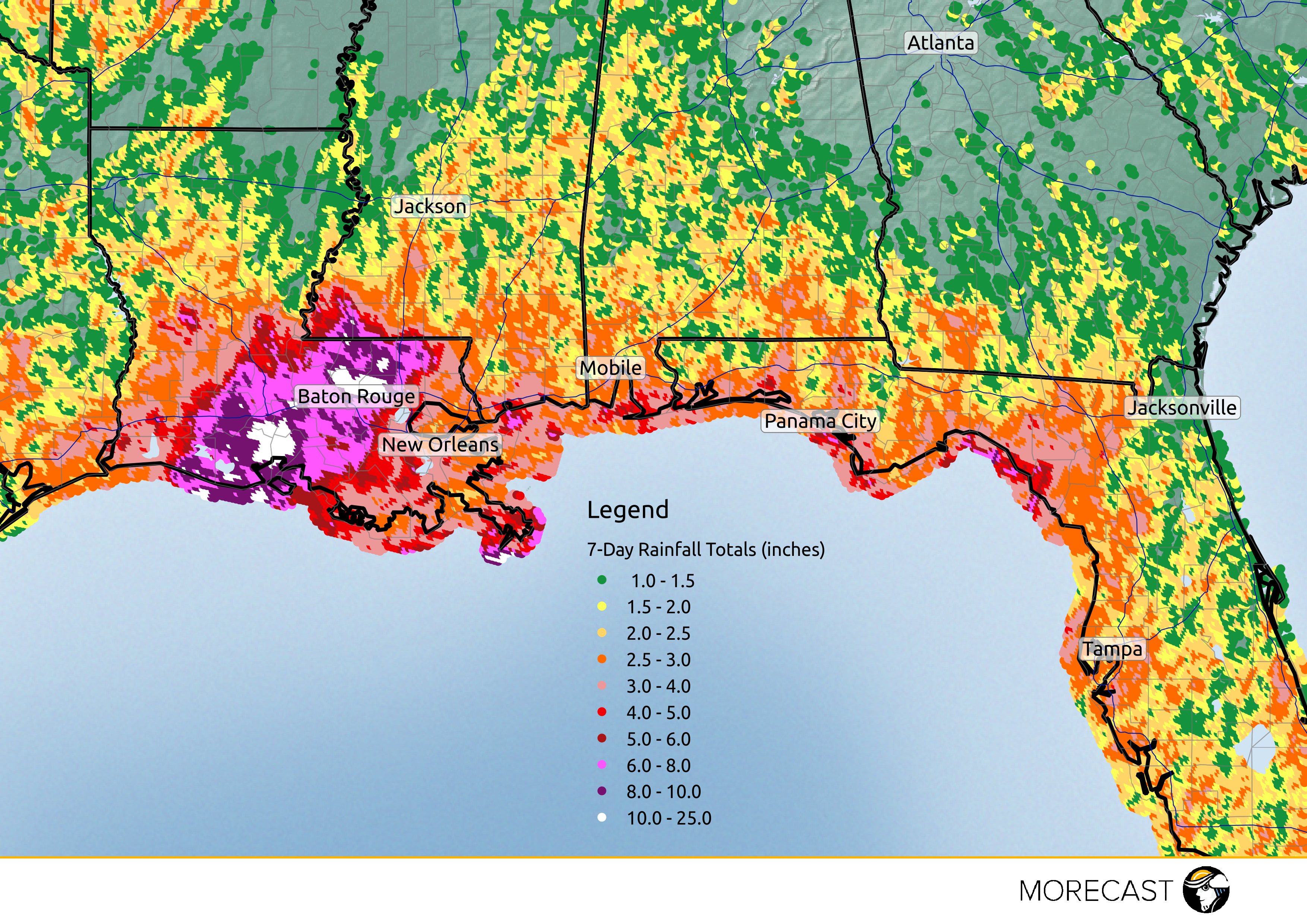
All of that water caused several streams and rivers to break their banks. Some gauges set all time records for levels above flood stage. In fact, the National Weather Service said the flooding was a 500 year event. This means statistically, an event like this would only occur once or twice a millennium.
The resultant flooding killed 13 people, while 20,000 people needed to be rescued. Around 60,000 homes were damaged or destroyed by the high waters, including several in areas that are not typically prone to flooding. Many homeowners did not have flood insurance, and will need state and federal assistance to rebuild. The cost of the damage is still being determined. However, the Red Cross anticipates it will be the costliest natural disaster in the U.S. since Super storm Sandy.
August Tornado Outbreak in Indiana & Ohio
While severe storms are possible anytime of the year, the month of August is not typically associated with tornado outbreaks. But that’s exactly what happened on August 24. The National Weather Service says at least 21 tornadoes touched down that day across Indiana and western Ohio. This would put the day in the top 10 of biggest August tornado outbreaks since 1950, and one of the bigger outbreaks of 2016. The strongest tornado that day was an EF3 in Kokomo, Indiana. With winds up to 165 mph, the Kokomo tornado lead to a dramatic video of a Starbucks being blown down.
This witness video of the Starbucks in Kokomo going down came from Brandon Mobley. He says he ran in to help pic.twitter.com/YP4qA0e2MX
— Tim McNicholas (@TimMcNicholas) August 24, 2016
The number of tornadoes caught most meteorologists by surprise. A chance for some severe storms existed in the Midwest. However, little indication suggested a tornado outbreak was in the cards that day, especially in Indiana and Ohio. Despite early forecasts, a small disturbance known as a mesoscale convective vortex (MCV) moved into the region that afternoon. The MCV developed from leftover storms in the Great Plains the day before. The nature of earlier thunderstorms determine the strength and nature of MCV’s. Because of this, forecasting models generally do a poor job resolving these features, making it difficult to provide a significant lead time for severe storms driven by the MCV.
Along with the high humidity, the MCV on August 24 created enough wind shear in the atmosphere for multiple supercellular (rotating) storms. These storms would eventually produce several tornadoes on this day. While forecasts may not have anticipated the outbreak, once the storms began, meteorologists got the word out quickly with no serious injuries or fatalities.
Extreme Heat
Several heat waves this summer have led to record breaking temperatures across portions of the country. In the Pacific Northwest, many Oregon cities broke records this August with highs in the 100s for Portland and Eugene. In southern California, Palm Springs reached a scorching 122 degrees this June, breaking the previous record. On the East Coast, stifling heat and humidity lasted for much of July and August. Washington, D.C. hit temperatures at or above 90 degrees 45 times from July through August, the most ever on record. New York, Boston, and Philadelphia each reached scorching temperatures with heat indices near 110 degrees in August.
However, it wasn’t just the US that had above normal temperatures this summer. May, June, and July have each set new monthly records for the hottest global temperatures on record. El Niño is partially to blame for the record temperatures, with above normal sea temperatures in the eastern Pacific Ocean warming the atmosphere. Despite these influences, past El Niño years did not reach temperatures quite as high as this summer’s, suggesting that El Niño was not the primary reason for the global increase in temperature.
Fires in Southern California & the West
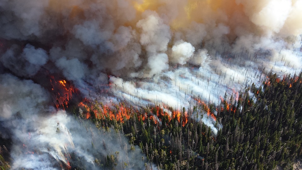
The summer months in the West are typically extremely dry, with little to no rainfall. Extreme heat in addition to the dry conditions make forests in the west susceptible to wildfires. Add in a 5 year drought for California and you have the perfect ingredients for a wildfire. In California, just 60 miles outside of Los Angeles, the San Bernardino forest fire became one of the most destructive fires of the year. The fire displaced more than 82,000 people, covered 37,020 acres and damaged 321 structures.
Further north, several wildfires occurred in Washington, Oregon, and Idaho this summer, causing major devastation for portions of the states. However, compared to the record setting fire seasons set in 2015 and 2014, this summer has seen a decrease in total fires and damaged acreage. Significant snow pack from the winter season in the Pacific Northwest likely lead to the decline in fires.
Tropical Weather
Hurricane season was relatively quiet throughout the first half of the summer. In late May, Tropical Storm Bonnie formed in the Atlantic ocean and made landfall near Charleston, South Carolina as a tropical depression. Although Bonnie was relatively weak, major flooding occurred in Georgia, North Carolina, and South Carolina with over 10″ of rain in some areas. Tropical Storm Colin followed closely behind Bonnie, making landfall in northeastern Florida. Strong winds and heavy rainfall from Colin led to power outages for more than 93,300 people.
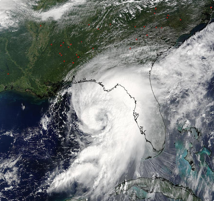
The summer time tropics ended with the development of tropical storm Hermine. On September 1st, just one day short of meteorological summer, Hermine reached hurricane strength and would later make landfall in St. Marks, Florida. Hermine would later cause millions of dollars in damage due to storm surge, flooding, and over 70 mph wind gusts. As the storm tracked north towards the East Coast, Hermine weakened to a tropical storm. Heavy rain and damaging wind gusts lead to additional damage for many residents from North Carolina to New York.