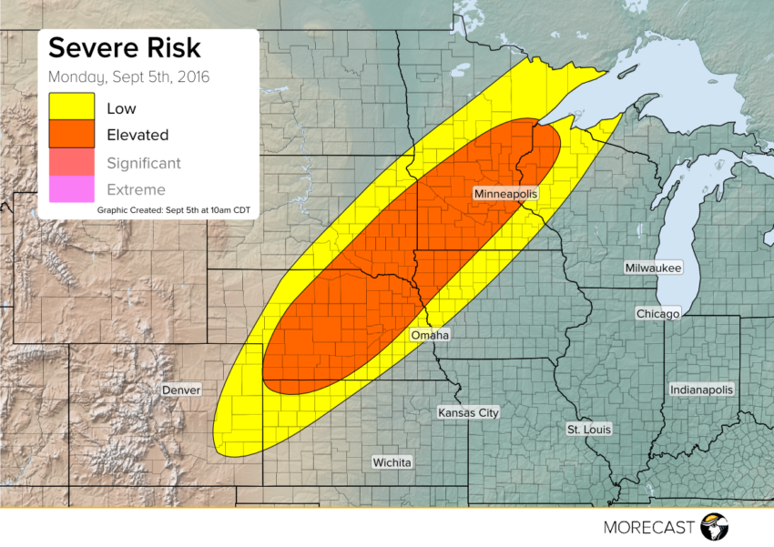
A frontal system stretches from Colorado to Minnesota this Labor Day. Due to the front, severe storms are forecast to develop in the Northern Plains later today.
For a second day in a row, severe storms will threaten the Northern Plains. Yesterday’s storms produced golf ball size hail and 60 mph wind gusts from Colorado to the Dakotas. As the front responsible for yesterday’s storms shifts to the east, a similar setup will occur today.
Beginning early evening, storms will begin to develop along the front. Severe storms are most likely to occur in Nebraska, South Dakota, and Minnesota. Similar to Sunday’s storms, strong wind gusts and hail will be the main threat. Although less likely, isolated tornadoes may occur as well.
In addition to the hail and strong winds, these storms may produce heavy rainfall. A risk of flash flooding exists primarily for South Dakota, Minnesota, and Iowa. Damaging storms will continue into the late evening with strong winds being the major concern.
While enjoying time outside for Labor day, residents in the Northern Plains should pay attention to local media. Storms can quickly become dangerous and life threatening.
MORECAST will continue to issue updates via our Twitter and Facebook pages as new details becomes available.
Follow @MORECAST_USA
