Tropical disturbance Invest 99L continues to churn through the Bahamas, showing occasional bouts of enhanced convection. We’re keeping a close eye on it as it nears the U.S. to see what types of impacts it could have for Florida and the Gulf Coast region.
Invest 99L periodically shows bursts of convection but there is no well-defined center of circulation to help it become a better organized tropical system. Atmospheric and land-induced shear continue to prevent Invest 99L from becoming a named tropical entity. Atmospheric shear has been on a downward trend over the past 24 hours and water temperatures are warm, so there is still a chance that this system could get its act together over the next few days.
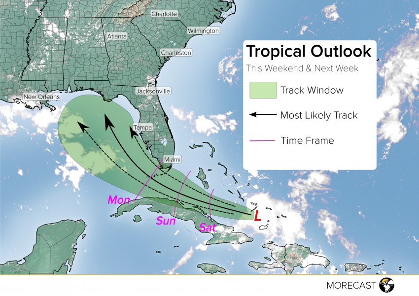
Some of the weather models suggest rapid intensification in the Florida Straits or the eastern Gulf, while some do not develop the storm at all, but the most likely path of the system will be westward through the open waters between Florida and Cuba before entering the Gulf of Mexico early next week. Once the system enters the Gulf, Invest 99L will be greeted by bathwater temperatures and be free from land interference, perhaps allowing for intensification. Interests in southern Florida should take action as heavy rains are likely through the beginning of next week with this storm.
MORECAST meteorologists will continue to monitor this system into next week. Although much uncertainty exists with the evolution of the system, preliminary precautions should be taken by those living along the Gulf coast. Keep an eye on government and local sources of weather information and be aware of shelter options and evacuation routes.
We’ll be issuing updates as well over our social media feeds (Twitter and Facebook) so stay tuned!