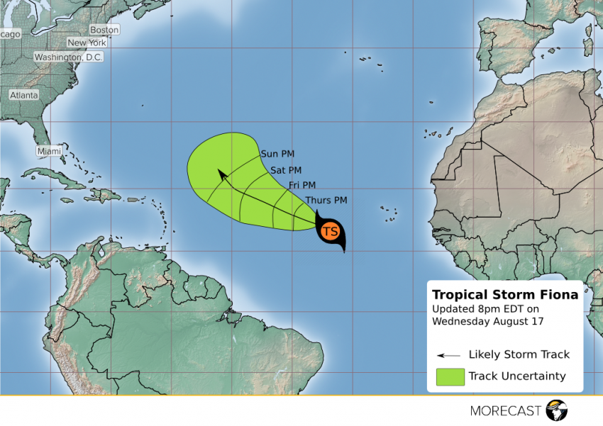
As August heats up, so does the Atlantic Ocean, adding fuel to potential tropical cyclones as we edge closer to the peak of hurricane season, which is typically just after Labor Day. It’s been nearly two weeks since Hurricane Earl ravaged the Yucatan and we have a new area to watch associated with a tropical wave coming off Africa. Wednesday afternoon, Fiona became the sixth named storm of the hurricane season, forming as a tropical storm in the middle of the Atlantic Ocean.
This year has been hot-and-cold so far for tropical cyclones. The first hurricane formed during the month of January, and two named storms had been observed before the start of the hurricane season on June 1. June saw two additional named storms before a lull through the entire month of July. One hurricane has already formed in August, and now Fiona is churning, though is nowhere near any land right now.
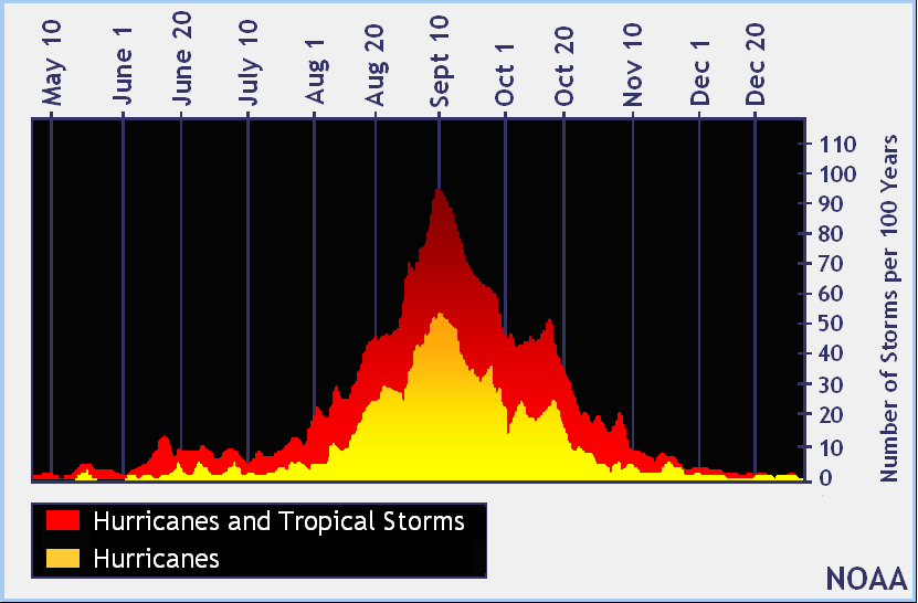
As you can see in the graph below, while the number of early storms this season was slightly atypical, the relative quiet in July compared to August is to be expected before a rapid uphill march to the statistical hurricane peak time of September 10.
Forecasters are paying attention to these statistics as well as the relative warmth of the Atlantic compared to average. Nearly the entire tropical Atlantic is warmer than average at this time adding plenty of fuel to would-be tropical cyclones. Using this information, the National Hurricane Center reiterated its call for an active season this year.
NOAA updated seasonal outlook released…still expected to be the most active since 2012. https://t.co/jlz3fToOQR pic.twitter.com/7QJ0j5owky
— Natl Hurricane Ctr (@NWSNHC) August 11, 2016
Knowing this info should make it no surprise that the second named storm of the month has formed off the African Coast. Tropical Storm Fiona is currently churning to the west of the Cape Verde Islands with sustained winds around 40 mph.

This storm has a somewhat uphill battle with will remain out to sea and should miss North America by a wide margin, although the small nation of Bermuda could be in its path. Fiona serves as an indicator that activity may be picking up. Computer models are showing signs of development of a pair of waves off the African coast in the coming weeks that could form additional storms. Seeing this should remind us that the peak of hurricane season is still ahead, and preparedness plans should be up to date in hurricane prone regions of the country.