Several states will receive a good soaking starting Saturday and continuing into Sunday across the Mid-Atlantic and much of New England, with downpours and localized flooding a concern.
A slow moving system has already started pushing a wide swath of scattered showers and thunderstorms into western New York and Pennsylvania as of Saturday morning. Pockets of rain, some heavy, will continue to develop and spread out Saturday afternoon all across Pennsylvania, much of New York state, New Jersey and Maryland, reaching parts of New England Saturday night.
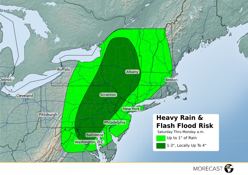
With lots of moisture being pumped in from the south and the slow progression of the storm overall, periods of rain will continue off and on for these areas into the second half of the weekend, with localized downpours at times with rainfall rates of one to two inches per hour. This will allow several locations, especially the eastern half of Pennsylvania, to pick up multiple inches of rain by Monday morning. Some localized amounts of 4″ to 5″ of rain will certainly be possible, which also increases the risk of flash flooding. Those driving should be alert for and avoid flooded roadways while also taking it slower on the wet roads, while people outside should use extra caution near rivers, streams, and areas where there is high water, especially in the Poconos and Catskill Mountains.
Major metros that will be soaked by the heavy rains include Washington D.C., Baltimore, Harrisburg, Allentown, Trenton, Scranton and Albany. Other cities including Philadelphia, NYC, Hartford and Boston may avoid the heaviest rains, but could still pick up an inch or so of rain by early Monday, if not more if a slow moving thunderstorm moves in.
Several interstates will also be in the path of the heavy rains:
I-80 from State College, PA to New York City
I-81 from Harrisburg, PA to Syracuse, NY (including Scranton)
I-87 through much of the Hudson River Valley
I-95 from Washington D.C. to New Haven, CT
While the storm will lose some strength by Monday, there will still be enough to keep light to moderate scattered showers going across the Northeast to kick off the new workweek.
UPDATE: Here are just some of the rain totals as of Sunday morning, and with more scattered rain expected during the day, some of these totals could go higher-
Berkeley Township, NJ: 5.99″
Near Dayton, NJ: 5.55″
Cold Spring, NY: 4.93″
U.S. Military Academy/West Point, NY: 4.91″
Pittstown, NJ: 4.03″
Moosic, PA: 3.83″
Berlin, CT: 3.62″
New Brunswick, NJ: 3.48″
Scranton/Wilkes-Barre, PA: 2.62″
The National Weather Service has a Flash Flood Watch in effect until Sunday evening for the southern Hudson Valley down into New York City, as well as southwest Connecticut (including Danbury, Bridgeport and Stamford) along with northeast New Jersey (including Milford and Newark)