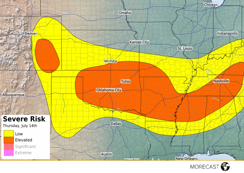
A frontal boundary will be draped from the High Plains of Colorado eastward through the middle Mississippi Valley this afternoon and evening helping to spark an elevated risk of severe thunderstorms.
Earlier Thursday morning, severe storms ripped through the Wichita airport with an observed wind gust of 81 mph knocking down trees and power lines in the area.
Hurricane force winds moving through Wichita and Sedgwick county. 80+ mph winds. #kswx
— NWS Wichita (@NWSWichita) July 14, 2016
These storms will move into an increasing unstable environment across Oklahoma and Arkansas this afternoon and evening leading to addition thunderstorms with damaging winds gusts over 60 mph and hail larger than 1 inch the main threats. The I-40 corridor from Oklahoma City to Little Rock will be at risk for potentially damaging storms this afternoon and evening.
Another cluster of storms pushing through the lower Ohio and Tennessee Valleys today will continue the elevated risk of severe storms along the I-40 corridor into Tennessee, including Nashville, with damaging winds the primary concern.
Lastly, upslope flow across the High Plains of Colorado will combine with moderate instability to help generate scattered strong to severe thunderstorms later this afternoon into the early evening hours. A few storms with containing a damaging wind and hail potential are expected.