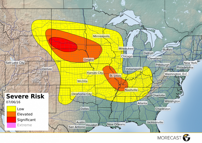
Parts of the Plains, Midwest, and Ohio Valley will be at risk of severe weather this afternoon and evening.
A low pressure system moving off the Rocky Mountains will combine with a system currently over the Plains to trigger severe storms across a large portion of the country.
The Black Hills of South Dakota eastward into southern South Dakota and northern Nebraska will see the most potent storms thanks in part to a frontal boundary set to be draped across the region in the afternoon. Scattered supercells will likely fire after 2 pm, and with extreme instability values, very large hail will be possible. The strongest cells will also be capable of producing destructive wind gusts as well as tornadoes.
In the mid Mississippi Valley and southern Ohio Valley, ongoing storm activity from Tuesday night and Wednesday morning will likely help trigger additional storm development Wednesday afternoon. Damaging wind will be the main threat, though small hail will be possible with stronger embedded storms.
Other isolated stronger storms can be expected across much of the Central/Southern Plains thanks in part to a frontal boundary draped across the area. For most activity in the forecasted “Low Risk” area on our map, strong wind gusts will be the main threat to watch out for.
As always, stay on top of the forecast with your MORECAST app!
