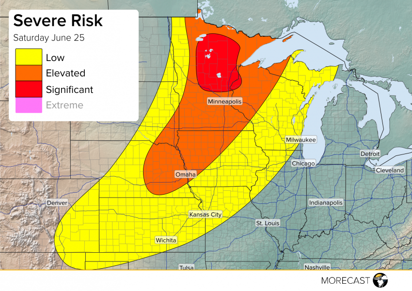
A cold front sagging through the Midwest and Central Plains extending from an area of low pressure in southern Canada will force a line of strong to severe thunderstorms this afternoon.
1PM CT Update:
Conditions destabilizing more than expected in north-central Minnesota prompting an upgrade to significant risk. Potential for very large hail to 1.5″ with occasional larger stones and damaging winds near 70mph in this area. An isolated tornado will also be possible in the strongest storms. Further south in the Twin Cities, the potential drops off somewhat, but large hail to 1″ is possible as well as winds to 65mph and an isolated tornado. Conditions south of Minnesota are following as expected and have not changed from the text below:
Morning storms pushing through the arrowhead of Minnesota extending southwest toward Minneapolis should push through before noon giving way to increasing sunshine. This will allow for the atmosphere to destabilize again before the cold front finally approaches during the afternoon and evening hours. The greatest risk for severe weather will be in northern Minnesota and northern Wisconsin with severe winds and some large hail possible as a line of storms pushes through. Further south storms along the front will become more scattered though anywhere north of Lincoln and Omaha Nebraska will likely see increased coverage.
Stay weather aware before heading out this Saturday afternoon and follow along with the MORECAST team on our Twitter and Facebook pages. Also be sure to upload any pictures you can safely take to your MORECAST app Follow @MORECAST_USA
