MORECAST takes a look at some ingredients needed for tornadoes to occur in New England and looks back on the 63th Anniversary of the Worcester tornado.
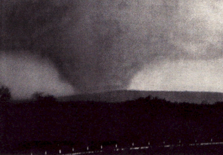
New England is known for having wicked Nor’easters and cold temperatures. However, the area is also susceptible to occasional severe thunderstorms capable of producing tornadoes. On June 9th, 1953, the strongest tornado ever recorded in New England was observed in Worcester, Massachusetts. The photo featured above was taken by Robert Resch from the intersection of Routes 9 and 20 on the southwest edge of Shrewsbury, Massachusetts.
EML (Elevated Mixed Layer)
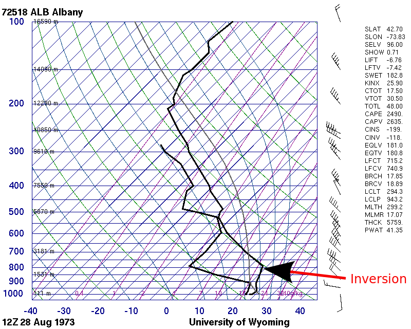
One atmospheric feature that has been linked to Northeast tornadoes is called the EML. From spring into summer, warm and dry air from the boundary layer descends off the mountains of the southwestern US. A layer of well mixed air, the EML, forms up to roughly 18,000 feet high which is approximately the 500 mb pressure level. A nearly dry adiabatic lapse rate forms roughly between 10,000 and 18,000 feet, or between 700 and 500 mb. The EML plume then ejects into the Plains and Northeastern US when a ridge of high pressure is present over the Mississippi River Valley.
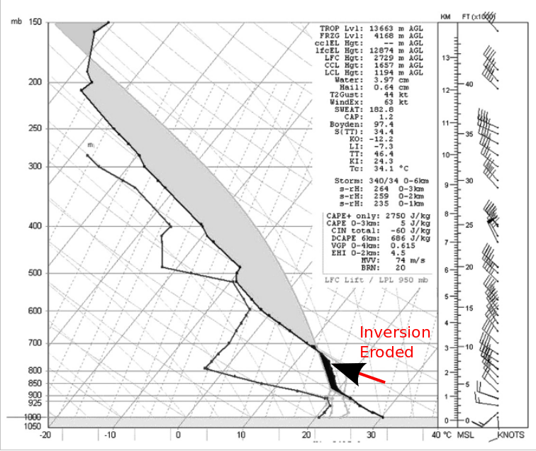
Two soundings below show an example of an EML evolution during the day. The first figure shows a sounding on the morning of August 28th, 1973 in Albany, NY. In the sounding, an inversion and capping are present which prohibits storm development. Also, an abundance of low level moisture is present with increasing dewpoint.
When looking at the afternoon sounding on August 28th, 1973 over Albany NY, the inversion and capping broke as energy was released. According to an American Meteorological Society journal titled “The Association of the Elevated Mixed Layer with Significant Severe Weather Events in the Northeastern United States”, the lapse rate roughly between 850-500mb was almost dry adiabatic, or around 8°C/km, allowed for rapid cooling. This cooling, combined with impressive instability values above 2500 J/Kg and good directional shear lead to some tornadic storms in the area that day.
Worcester Tornado
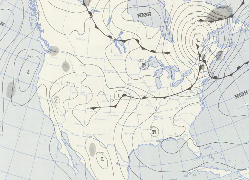
On June 9th 1953, a severe weather outbreak took place across New England. A Surface map below shows the setup of a warm front moving during the morning, allowing for a moist unstable airmass to develop. Supercellular storms fired ahead of the cold front later in the day.
As the weather pattern unfolded, forecasters from the Boston area were conflicted on whether or not to include tornadoes in the New England regional forecast for fear of panic. Believe it or not, 1953 was the first year the National Weather Service ever issued tornado and severe thunderstorm warnings across the country. In regards to June 9th, 1953, the National Weather Service in Boston issued its first ever severe thunderstorm watch for the state of Massachusetts but didn’t mention tornadoes as a threat. This would prove to be costly as the Worcester tornado would strike many citizens with little to no warning.
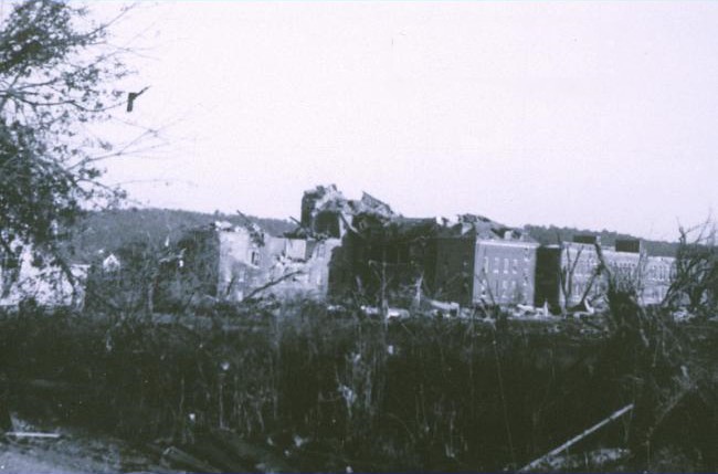
The Worcester tornado formed around 4:30 PM that afternoon over the Quabbin Reservoir, according to local boaters. It began as a series of smaller funnels until it became a massive 1 mile wide monster as it entered northern Worcester around 5:08 PM. It maintained its width through the northern part of the city. Assumption College was amongst the hardest hit buildings and can be seen in the photo below.
The tornado lasted until about 5:45 PM. Unfortunately, no tornado warnings were issued on the storm until it had dissipated over Framingham, Massachusetts. The storm traveled almost 50 miles and was on the ground for nearly 90 minutes. Officially, 90 people were killed with an additional 1,000+ injured. The tornado caused more than 50 million dollars in damage at the time, equivalent to 500 million dollars today. It also set a record for leaving more than 10,000 people homeless. The Worcester tornado left a historical mark on the United States by leading to the reorganization of what is now the Storm Prediction Center. It also led to the implementation of a nationwide radar/storm spotter system. Since June 9th, 1953, the results of the new changes were proven to be successful as no U.S tornado killed more than 100 people until May of 2011 when Joplin, Missouri was hit. Once all the damage had been surveyed, the NWS determined that the Worcester tornado was classified as an F4 on the Fujita Scale which was developed in 1971. According to this scale, the Worcester tornado received second highest rating with a storm having estimated wind speeds between 207 and 260 mph. Below is a photo that depicts damage done to a neighborhood while the tornado was at peak intensity.
