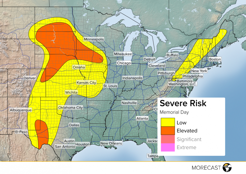
Memorial Day marks the unofficial start of summer and Mother Nature is heating up the severe potential in the central US. An isolated severe threat extends from the Dakotas through Texas as well as the Northeast. Here’s a look at what you could see today as you hit the pool or have a barbecue.
There are two separate areas with an elevated risk for severe activity Memorial Day, one in the northern Plains and Upper Midwest and another in the Big Bend of Texas. In the north, a developing surface low will focus strong to severe thunderstorms along the warm and cold front. Near the surface low along the North Dakota/South Dakota border lies the greatest chance for an isolated brief tornado with strong winds to 65mph and large hail to 1.5″ the primary threats for the remaining elevated area. Further storms along the dry line in far southwestern New Mexico and the Big Bend region will likely produce very large hail, potentially to 3″+, and gusty winds to 65mph. An isolated threat also exists for small hail and occasionally gusty winds in the higher terrain of the Appalachians in the Northeast as a cold front approaches from the west. Be sure to look at the weather before you head to any outdoor activities this afternoon in these locations.
Stay up to date as the storms develop by following along with MORECAST on Twitter Follow @MORECAST_USA and be sure to upload any pictures you can safely take to your MORECAST app.
