Could a La Niña follow one of the strongest El Niños on record? Recent declines in Pacific Ocean temperatures are showing hints of a lurking La Niña. With El Niño likely on the way out, what could La Niña mean for your weather in the year to come?
What is El Niño/La Niña?
When ocean temperatures in the equatorial Pacific Ocean are significantly above normal, we refer to this as El Niño. La Niña refers to the exact opposite conditions, with ocean temperatures well below normal. Both El Niño and La Niña have a major impact on the normal weather patterns, causing some regions to be more wet, hot, dry or cold.
Is La Nina next?
After this year’s El Niño reached it’s peak strength in November of 2015, ocean temperatures began to steadily decrease. Recent temperatures are indicative that the current El Niño will come to an end by early summer and enter a neutral stage. What happens after is the big question. Will we remain in the neutral area or will temperatures continue to decrease into La Niña conditions?
If scientists based their answer on past El Niño events, their answer would lean towards La Niña. In past years, most strong El Niño years were followed by La Niña conditions, which makes sense when thinking in terms of atmospheric physics. El Niño produces atmospheric circulations that in a way, eventually sabotages itself and leads to ocean cooling. However, during some El Niño events, La Niña conditions didn’t occur until a year after an El Niño. In addition, there is a short record of these events, meaning it’s hard to define a definite correlation between the two.
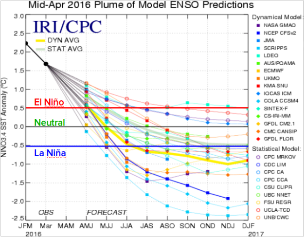
But scientists look at more than what has happened in the past. They use complex climate models, current observations, and temperature trends. Current conditions have shown a continual cooling trend and much colder waters beneath the surface, indicative of a transition to La Niña. In addition, researchers at the International Research Institute (IRI) of Climate and Society and the Climate Prediction Center (CPC), use multiple models to find a general consensus on what models are predicting. In the graph produced by IRI and the CPC below, we can see most models predict well below normal sea surface temperatures by late summer or early fall, meaning La Niña is likely.
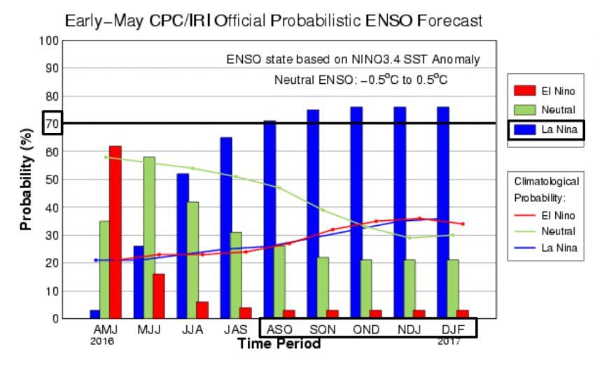
The probability of La Niña occurring has been increasing every month, with the IRI and CPC now estimating a 75% chance of La Niña occurring by fall. Based on these numbers, NOAA has officially announced a La Niña Watch. Although slightly unusual, some models have even hinted of La Niña appearing by late summer. However, this forecast doesn’t guarantee a La Niña year. A lot of time remains before the Pacific Ocean temperatures might shift below normal and there’s still a 1 in 4 chance of temperatures remaining in the neutral or even El Niño stage.
How would La Niña impact the United States?
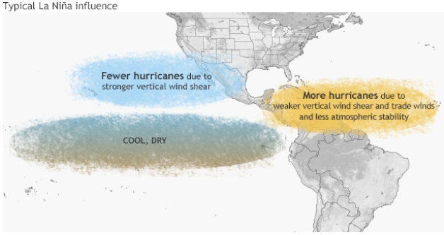
La Niña typically has the biggest impact during the winter season. However, if La Niña occurs in the summer months, this could have implications on the hurricane season. Even though the waters in the eastern Pacific Ocean are cold, the opposite is true in the Atlantic Ocean. Warmer waters in the Atlantic make a more favorable environment for hurricanes to form, as well as weak vertical wind shear, which is why hurricane season is typically more active during La Niña years.
During the winter months, La Niña shifts the typical pattern of the jet stream. Because of the shift, the Pacific Northwest typically sees above average precipitation, as do portions of the Great Lakes and the Ohio River region. Alaska, western Canada and the central North US experience colder temperatures and in the South, conditions are much drier and warmer than normal. With below normal precipitation in California, drought conditions could worsen. However, it’s important to remember that La Niña only increases the chance of certain deviations from normal conditions. In other words, places like California could still see near or even above average rainfall, despite La Niña decreasing that likelihood.
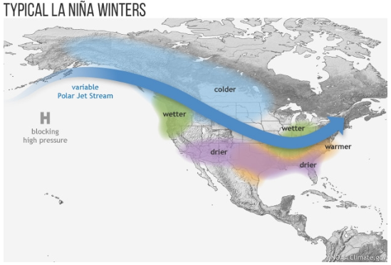
During the winter months, La Niña shifts the typical pattern of the jet stream. Because of the shift, the Pacific Northwest typically sees above average precipitation, as do portions of the Great Lakes and the Ohio River region. Alaska, western Canada and the central North US experience colder temperatures and in the South, conditions are much drier and warmer than normal. With below normal precipitation in California, drought conditions could worsen. However, it’s important to remember that La Niña only increases the chance of certain deviations from normal conditions. In other words, places like California could still see near or even above average rainfall, despite La Niña decreasing that likelihood.
Despite some uncertainties, the chances of a La Niña event occurring by fall continue to increase. In the coming months, sea surface temperatures will begin to show stronger indications of either La Niña or a neutral phase. Check back with MORECAST in the coming weeks for the latest La Niña updates.
