UPDATED Monday afternoon:
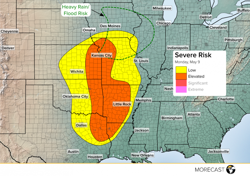
A slow moving storm moving through the interior U.S. will fire off strong to severe storms starting late Monday afternoon and continuing into the evening for portions of the Central and Southern Plains, the Ozarks and the ArkLaTex region.
The highest risk for tornadoes will be in ArkLaTex and eastern Oklahoma, including places such as Shreveport, Louisiana; Tyler, Texas; Little Rock, Arkansas and Tulsa Oklahoma. Along with tornadoes, large hail greater than 2″ in diameter and damaging winds will be possible.
Another cluster of severe storms will fire in eastern Kansas before moving into western Missouri, likely forming into a line. While a couple isolated tornadoes are possible, the main threat will be straight line winds and hail. Metros at risk include Topeka, Kansas and Kansas City, Missouri.
Isolated storms will also be possible in and around Wichita, Kansas and Oklahoma City. While the overall chance for a storm is smaller in these places, any storms that are able to develop will do so rapidly, so be alert to quickly changing weather conditions.
Meanwhile, a threat for heavy rain which may lead to flash flooding will continue across northern Missouri, western Illinois and eastern Iowa. If you’re in these areas, be alert along creeks and streams and watch out for flooded roads.
