It’s been five years now since the largest tornado outbreak in American history began unfolding. A total of 363 tornadoes touched down between April 25 and April 28, 2011, leaving destruction across 21 states. Four tornadoes even reached EF5 strength, the strongest on the Enhanced Fujita Scale with winds greater than 200 miles per hour. The four monster twisters in a single outbreak was more than the U.S. typically sees in a whole year. MORECAST meteorologists recap what remains the deadliest outbreak since 1925, as well as some of science behind what caused it.
On April 25, a potent upper-air trough (an area of low pressure, meaning upward motion in the atmosphere) moved out of the High Plains and into the Southern Plains and Southeast. With high instability across the region, supercell activity kicked off in the afternoon. The first violent tornado (EF3 or greater) of the outbreak struck Hot Springs Village, Arkansas, in the evening hours. Elsewhere, a massive EF2 tornado ripped through Vilonia, Arkansas, with the town under a tornado emergency. The same town was devastated by an EF4 tornado, almost three years earlier to the day.
The next day on April 26, the system that fired storms a day earlier pushed northwards towards Canada. A secondary area of low pressure formed in Northern Texas along a cold front draping down from Michigan into Texas. For the second day in a row, areas around the Texas/Arkansas/Louisiana border went under the severe weather gun. A long track EF2 ravaged rural areas of Texas and Louisiana. Further north, an EF3 touched down in Kentucky. Several supercells with tornadoes, large hail and winds were also spawned from Michigan to New York.
April 27 brought the most destructive day of the outbreak, and in tornado history. The low pressure center from Texas had progressed northeastward towards the Great Lakes. The progressing system pulled its associated cold front slowly eastwards, draping it through the Ohio and Tennessee Valleys into Mississippi and Alabama.
With storms still ongoing from the previous night, a squall line moved through Louisiana, Mississippi, and eventually onto Tennessee and Alabama. As the line barreled eastward, it gained strength, tapping additional moisture from the Gulf of Mexico. Weak tornadoes are somewhat common with such storms, and this was no exception. Many EF0 and EF1 tornadoes were reported, and exceptionally, two EF3’s. One of the two strongest tornadoes impacted Cordova, Alabama, which would be hit by a second tornado later in the day.
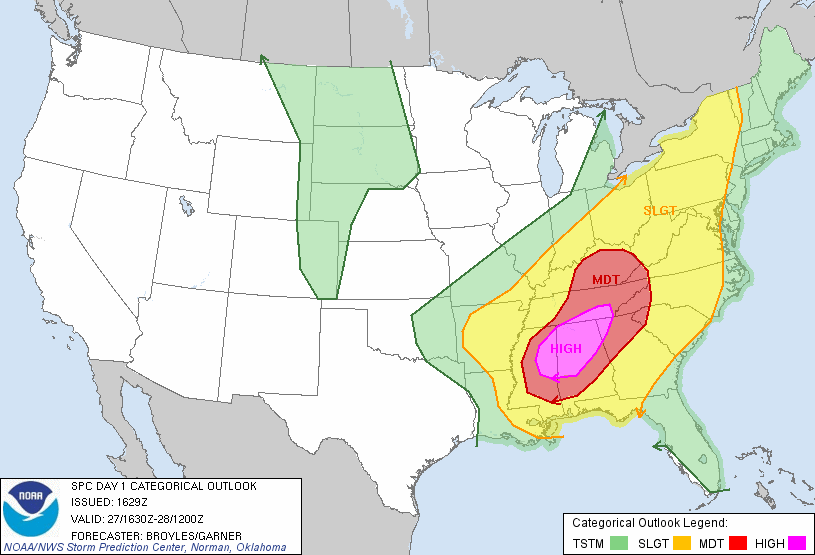
Conditions across much of the Southeast became more and more favorable for long track, violent tornadoes throughout the day. Low level moisture pushing up from the Gulf combined with increasing wind shear to create a deadly concoction of tornado and severe weather ingredients. With instability reaching extreme amounts, a mid-level jet streak with 90-100 mph winds blasted in over Mississippi and Alabama. Dew points in the 70s finalized the near perfect setup for tornadoes, prompting the Storm Prediction Center to issue a “Particularly Dangerous Situation” tornado watch.

Mid-afternoon brought the first of many intense storms, as an EF4 twister ripped through Cullman, Alabama. Previously mentioned Cordova was hit by an EF4, compounding a hugely unlikely double hit in a single day. Intense tornadoes continued through the evening, though one stands out as particularly destructive…

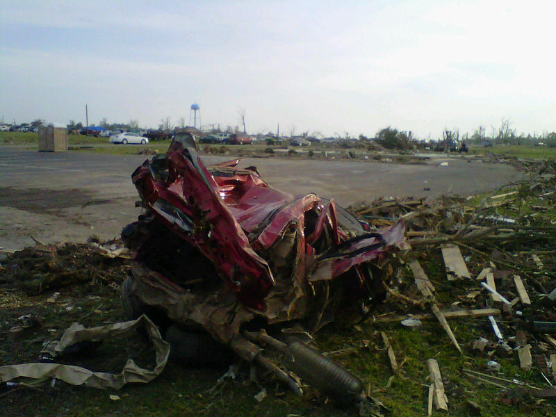
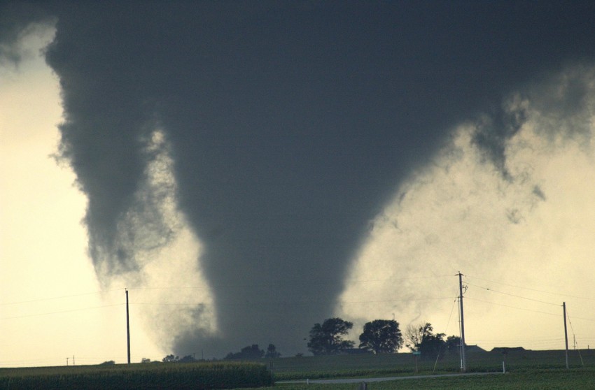
A supercell originating in Mississippi quickly intensified as it moved into Alabama, producing a large wedge tornado as it moved over rural areas in the west of the state. With such a favorable environment, it quickly became clear that this storm would track an exceptional distance with extreme strength. As the storm roared forward into Tuscaloosa County, local news stations and spotters began streaming live images of a violent tornado on the ground. The tornado entered the city of Tuscaloosa, leveling structures and throwing vehicles like toys. As the twister progressed, it continued to cause astounding damage – including carrying boats over 300 feet from their berths and throwing a 35-ton bridge support up a hill.

With the tornado moving out of Tuscaloosa, residents of Birmingham started reporting debris falling from the sky. The twister had managed to pull up small pieces of material – wood, leaves, lightweight plastics – into the main structure of the storm, and redistribute it well ahead of the tornado itself. Unfortunately for the residents of Birmingham, the debris signaled what was coming, as the tornado maintained its strength and moved into the city limits, around 50 minutes after it had pushed through Tuscaloosa. After causing further, incredible damage in the western and northern suburbs, the monster began weakening. It eventually dissipated over a far northern suburb of the city, leaving an 80 mile scar on the landscape of Alabama. The parent storm went on to travel an astonishing 380 miles over 7 hours, from Mississippi to North Carolina

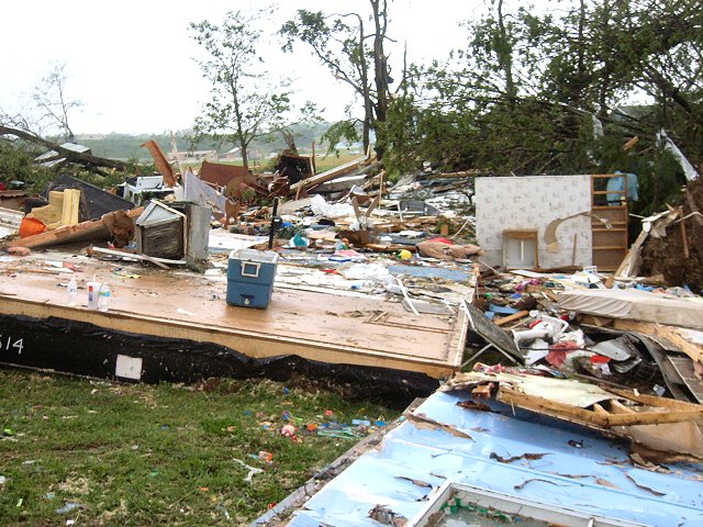
Despite the amazing extent of damage, the Tuscaloosa tornado was only rated an EF4. With the majority of structures that were leveled or lifted into the air only being nailed to their foundations rather than bolted, EF5 damage could not be assessed by all damage survey teams. At the end of the day, ten other EF4, and four EF5 tornadoes across the Southeast – an unprecedented number of violent tornadoes for a single day.
April 28 ushered in the end of the the severe weather barrage on much of Southeast, with activity shifting north and east. As the culprit system pushed north into Canada, the associated front sparked tornadic supercells and thunderstorm lines from Florida to New York. An EF3 fatally struck Glade Spring, Virginia, before the final tornadic storms moved off the North Carolina coast.

The outbreak claimed 324 lives, the majority of which were from the violent tornadoes of April 27. Of the 363 confirmed tornadoes, 211 touched down in only a single 24 hour period. The $11 billion in damages remains the costliest tornado outbreak in history, and more costly than the majority of hurricane landfalls. Less than a month later, the most costly single tornado in history would devastate Joplin, Missouri, continuing the exceptional 2011 severe weather season.
Credit for photographic content to the National Weather Service, Weather Prediction Center, Storm Prediction Center, and NOAA.