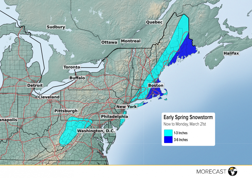
Models continue to shift the track of this weekend’s storm slower and more offshore with the best chance for heavier snow affecting coastal New England on Monday. Several inches of wet snow accumulation are still likely to occur but the area to be affected has shrunk to Rhode Island and eastern Massachusetts, including metro Boston, as well as Downeast Maine. A few elevated spots could see up to 6-7 inches of accumulation.
The system affecting the region has failed to consolidate as earlier predicted, so that instead of one strong low moving up the coast, several pieces of energy are rotating through with the last likely to exit into Maritime Canada late Monday. The area affected by accumulating snow has thus become restricted, leaving cities like Philadelphia and New York unlikely to see more than an inch or so. However, Boston and surrounding areas are still likely to see a significant early spring snowstorm.
Winds will increase along the coast on Sunday night into Monday as the low pressure intensifies, which combined with the sticky, heavy nature of the snow could lead to numerous power outages. Air and ground travel conditions will become hazardous with delays and detours affecting many.
Your MORECAST app will keep you informed about the latest updates – try the Navigate feature for a detailed route forecast if you do have to travel! Keep an eye on our Facebook and Twitter pages as well for additional information about this developing storm.
