A series of storm systems starting Friday and continuing into Tuesday will bring rain and snow to the western half of the country. As a strong jet stream drives in moisture rich air into the western United States, several areas of California, Oregon and Washington will see heavy rain and snow.

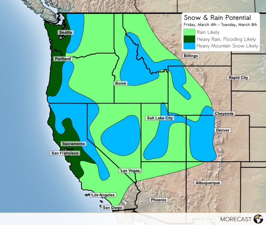
A foot or more of snow is possible for portions of the Sierra and Cascade Mountains over the weekend in addition to strong winds. The higher elevations of Idaho, Montana, Colorado, Utah and Nevada are also expected to see snow begin on Sunday with accumulations of 3 to 8 inches. Conditions along roadways and passes in these higher elevations will be hazardous and travelers are urged to use caution if driving along these routes.
For the coastal regions, heavy rain is forecast from Friday through Tuesday with total accumulations ranging from 1 to 5 inches, including for the Bay Area. Even the Central Valley, including Sacramento, could pickup multiple inches of rain as separate Pacific storms move into the area, leading to on and off rain for much of the west. The much needed rain will likely help reduce drought conditions in some areas. However, persistent, heavy rains increases the risk of flooding and mudslides. Residents in this area are urged to use caution when driving through flooded roadway.
Sunday will bring heavy rains to portions of Southern California, including in Los Angeles, with 1 to 2 inches of rain falling. An additional round of rain expected on Monday as well. Local flooding is expected with some of the heavier showers, and some mudslides cannot be ruled out.
East of the western mountain ranges, rainy conditions will begin early Sunday with much lighter accumulations than the coastal and foothill regions. Half an inch of rain is expected to fall from Sunday into Tuesday. A short break from the rain and snow will occur on Tuesday before the next round of storms is expected to bring back wet conditions to the western region. A full breakdown of the areas impacted by the series of storms are shown below.

