The tornado outbreaks that have devastated areas from Louisiana through Virginia over the past few weeks might suggest the onset of a busy 2016 tornado season. However, MORECAST meteorologists are focusing on unusually warm waters lingering over the equatorial Pacific that could actually serve to dampen severe activity in “Tornado Alley”.
Powerful twisters have spun across sections of the South and Mid-Atlantic in the past few days, unusually early signals of the approach of the spring tornado season. The EF2-rated tornado that hit Lancaster, Pennsylvania Wednesday evening was only the second tornado of any intensity to hit that state in February in the past 65 years, followed just hours later by an EF1 almost up to the New York state border. Two EF3-rated tornadoes with a combined path length of 41 miles caused numerous injuries in southern Virginia, while three people lost their lives to the EF1 that smashed Waverly, Virginia. High-end EF2 to EF3 tornadoes roared across densely populated areas near New Orleans, Louisiana and Pensacola, Florida on Tuesday with winds up to 155 mph.
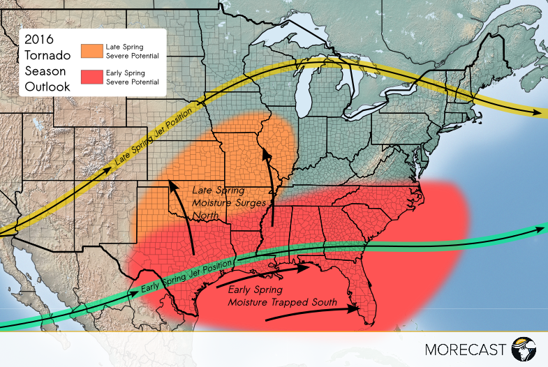
These ferocious early-season tornado outbreaks might send a familiar chill down the spines of residents of the Plains occupying what is traditionally known as “Tornado Alley”, the region from Texas to Nebraska that typically sees the most concentrated and strongest tornadoes in the world. An early start in the South might suggest a threat for tornadoes aiming for the Central Plains in March and April rather than the climatologically favorable May to June time frame. However, the very factors that have contributed to the recent tornadic activity in the South may actually inhibit the severe weather season further west and north for much of this spring.
Unlike hurricane seasonal forecasts that have been issued by various agencies for decades, the idea of forecasting the tornado season is relatively new. Tornadoes are short-lived and subject to very localized forcing mechanisms typically beyond the scope of long-range models. We can, however, forecast the large-scale factors that might favor a tornado-friendly environment. Those factors include the availability of Gulf moisture and the potential for atmospheric spin, both of which are highly dependent on the position of the jet stream, which is in turn influenced by the phase of the ENSO, the variation in eastern Pacific sea surface temperatures that has global weather implications.
The current warm (El Nino) phase has waned from its near-record peak in December, and is expected to transition to a neutral or cool La Nina phase later in the summer. However, in its dying stages, El Nino will continue to exert a considerable influence over U.S. weather patterns, including a suppression of the jet stream south which would inhibit the tornado threat over the Plains. What could represent good news for residents of Kansas, Nebraska, and the Midwest may not be so welcome across the South, including Florida. An active southern jet stream could translate into more bursts of tornado activity such as the ones that have plagued the region in the past few weeks. Indeed, Florida’s deadliest tornado outbreak ever occurred in late February of 1998, during perhaps the strongest El Nino on record. Conversely, the infamous tornado outbreaks of 1974 and 2011 that affected areas well to the north and west occurred during La Nina conditions.
Our team of experienced meteorologists will be issuing special outlooks and updates during busy severe weather situations via the MORECAST app as well as our Facebook and Twitter pages – stay tuned!

