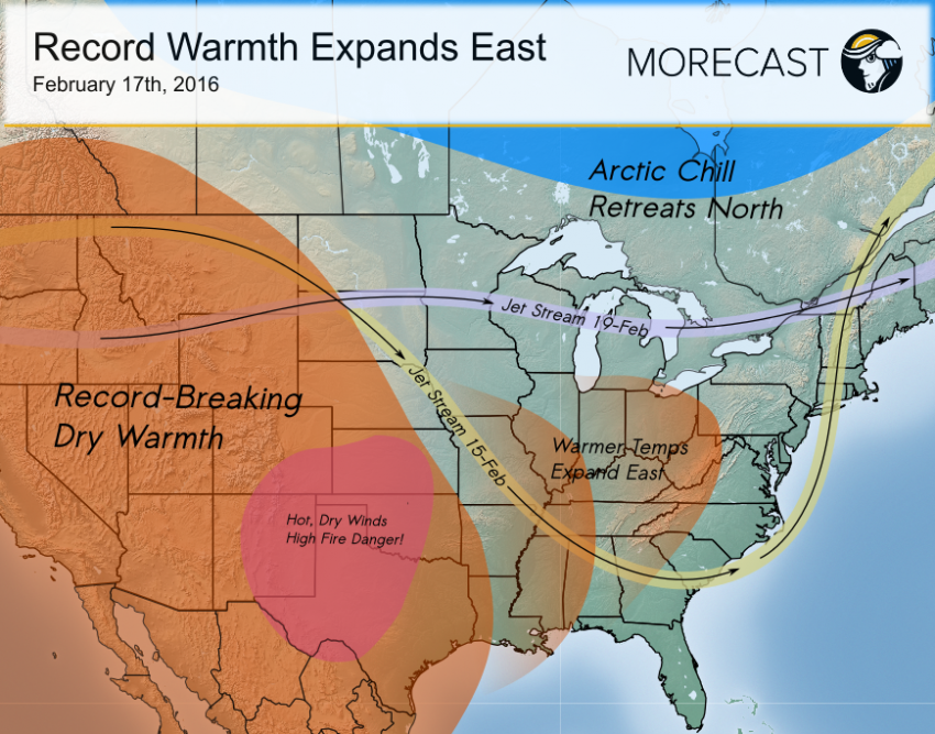
After a much wetter-than-normal January across most of the West, especially from northern California up into the Pacific Northwest, a strong, stagnant ridge of high pressure has dominated early February weather, resurrecting the threat of drought. This dry heat is spreading east, bringing an extreme fire danger to parts of the High Plains.
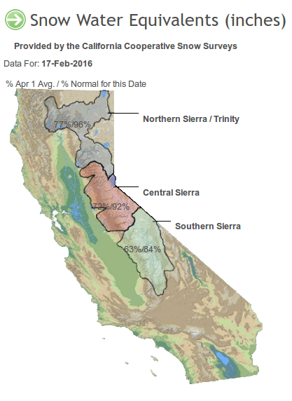
Widespread swaths of above normal precipitation were observed from California up through the Pacific Northwest in January. Redding, California saw more than 12 inches of rainfall in January, but so far in February only 0.09 inch has fallen. The unwelcome return of dry conditions has been accompanied by a winter heat wave. Downtown Los Angeles has seen ten days in a row with highs of at least 79 degrees, including six of those days at or above 87 degrees, at a time of year when highs should only be averaging around 70 degrees. Daily maximum temperature records were set on Feb. 8 and 9, as well as Feb. 15-17. Record highs have been recorded even in the normally mild Desert Southwest. The warm, dry weather has allowed the Sierra Nevada snowpack to fall below normal for the first time this season (see graphics below comparing snowpack from early versus mid-February). A snow storm affecting the mountains today will provide only a temporary respite from the downward trend.


Record warmth has reached as far north as Canada, and is threatening to expand eastward as the jet stream pattern shifts from amplified to zonal (see graphic above), allowing the warm bubble to shift towards the Central U.S. Records will be threatened in the next few days from Denver, Colorado to Wichita, Kansas to Amarillo, Texas and many points in between. Even in the East, the arctic air mass that produced record cold last weekend has retreated back to the north as quickly as it came down, allowing temperatures to quickly rebound back to near or even just above normal. Melting snow and heavy rain has led to flash flooding in some of the major cities.
In the Plains, the record heat is being accompanied by damaging winds, gusting up to 70 mph in some wind-prone spots. The combination of a lack of precipitation, record heat, and high winds will create dangerous fire conditions, especially on Thursday. This fire danger will be especially acute from Kansas and western Oklahoma into the Texas Panhandle, eastern New Mexico, and southeast Colorado. Any fire that starts in these areas will likely grow quickly out of control. Intentional outdoor burning would be highly inadvisable and outdoor fire bans from local governments will be prevalent.
The warm, zonal jet pattern looks to be short-lived with another deep trough potentially carving itself out across the East by the middle of next week. Such a pattern could support another big East Coast storm, although the lack of a tap of true arctic air might limit the threat of heavy snow to the interior with rain affecting the urban corridor. Stay tuned to the MORECAST app for the latest forecast updates!
