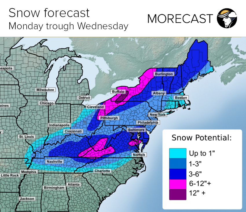
A messy commute is expected for much of the Eastern US as a new system will move into the region Monday, bringing a mixture of rain, ice and snow through early Wednesday morning. MORECAST takes a look at when and where to expect rain or snow this week.
Heavy rain will begin Monday morning in Arkansas and Western Tennessee with portions of these states forecast to receive as much as 2.5” of rain. Rain will fall across the Gulf states and the Southeast Monday afternoon and continue into the next day. Severe thunderstorms could threaten southern Louisiana, Mississippi and Alabama Monday afternoon with the potential of producing strong wind gusts and an isolated tornado.
Today, the snow and ice has already impacted eastern parts of West Virginia and along the border between Kentucky and Virginia. This will eventually transition to mainly rain by Monday evening. Snowfall amounts of 6-12” have fallen over higher elevations of the Appalachian mountains, while lower elevations having received under 6″. Areas to the east over the Mid-Atlantic , 1-3″ of snow has fallen across northern North Carolina and southern Virginia. 3-6″ of snow has accumulated, stretching from central Virginia through the Delmarva Peninsula. This includes the Washington DC and Baltimore metro areas. A localized zone of 6″+ has fallen to the south of Washington DC.
Icy conditions will stretch from northern South Carolina to southern New York Monday into early Tuesday before it switches over to rain. The cold temperatures from this past weekend will make surface temperatures stay below freezing, allowing rain to more easily turn into ice. Roads are expected to be icy throughout most of this region, causing major impacts to commuters on Monday.
By Tuesday morning, the rain in the south moves further east towards coastal states. Warmer air causes the freezing rain and snow in West Virginia to transition into a chilly rain. Temperatures remain cold enough for snow in Pennsylvania as well as New York on Tuesday. Major cities such as Philadelphia, New York City, Washington D.C. and Baltimore could see a mixture of snow and rain Monday and Tuesday, although most of the precipitation will fall as rain or an icy mixture. Snow accumulations are expected to be around 1-3” in the big cities. Away from the cities, 3-6″ of snow is likely across higher elevations of northern New England, upstate New York, western Pennsylvania, and eastern Ohio. Major Cities Affected include burlington, VT and Binghamton, NY. 6-12″ of snow will accumulate across parts of eastern Ohio, northwest Pennsylvania, and western New York. Major Cities impacted include Erie, PA; Buffalo, NY; Rochester, NY; and Syracuse, NY. A narrow zone of 12″+ is possible across the Finger Lakes region of New York. The snow is expected to end by early Wednesday.
The snow and ice expected from Monday through Wednesday will lead to slick roads. Those commuting Monday evening and during the day Tuesday can expect widespread delays and messy roads. Take caution when driving in snowy or icy conditions as the roads could become extremely dangerous. Make it easier to create travel plans while staying up to date on the weather forecast by using MORECAST’s navigation feature.

