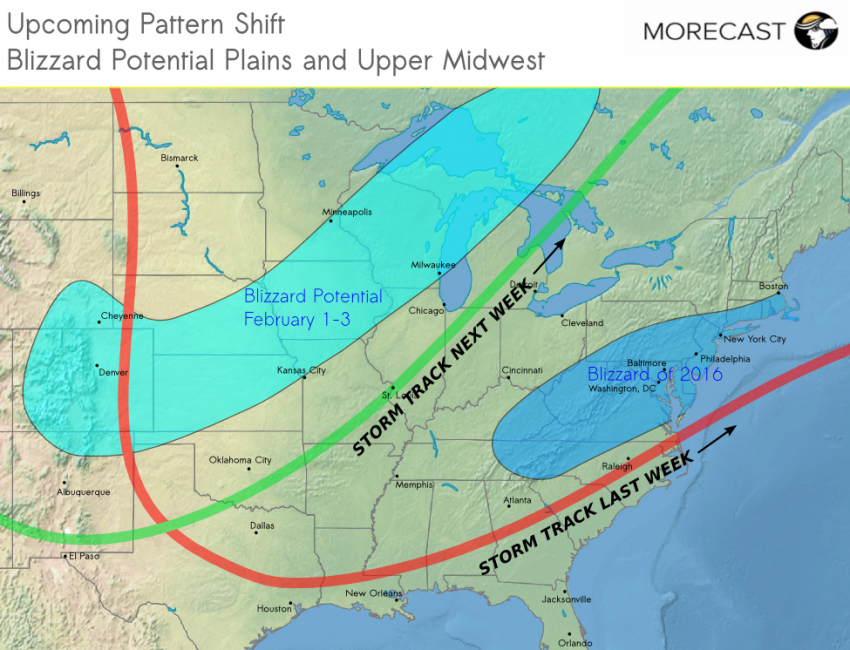
A few weeks ago MORECAST meteorologists noticed a shift in the global weather patterns that indicated the odds were increasing for a big East Coast snowstorm. Sure enough, the Blizzard of 2016 struck the major population centers from the Mid-Atlantic through New York City over the past weekend, 22-23 January. Another significant shift in the jet pattern is underway. Where will Old Man Winter cast his icy gaze next?
MORECAST meteorologists anticipated the pattern shift of a few weeks ago and the associated increasing likelihood of an Nor’easter snowstorm partly by looking at the global models, such as the new and improved GFS and the standard-bearing European model, but we also noted telling changes in teleconnection index values. Atmospheric “teleconnections” are anomalies in climate features that have a major influence on the way smaller-scale weather systems develop and move along the currents of upper air wind flow. One of the most famous and important teleconnections is the ENSO, the warm phase of which is known as El Nino. In fact ENSO is comprised of two variables, one atmospheric and one oceanic, merged together due to the intertwined nature of the physical mechanisms. The current El Nino is one of the strongest ever recorded and has had major impacts on weather across the Western Hemisphere for the past several months.
Among the more relevant “local” teleconnections are the NAO (North Atlantic Oscillation) and AO (Arctic Oscillation), for which the NOAA’s Climate Prediction Center issues daily updates and forecasts. In mid-January both indices bottomed out, a pattern typically associated with cold air plunging down from Arctic that occasionally sparks the development of intense winter storms such as the now infamous Blizzard of 2016. Conversely, a positive phase of both the NAO and the AO is typically associated with mild, wet weather in the eastern half of the U.S. during the winter months. The NAO and AO indices have been trending sharply positive in the last week or so, meaning not only a rapid melting of the heavy snow that fell last weekend, but a shift in the predicted storm track from the East Coast to the Central U.S. In addition, while the El Nino likely peaked several weeks ago, it remains strong, maintaining a tap of Pacific moisture directly into the southern and eastern U.S.
Low pressure will move across California and the Desert Southwest Sunday, providing beneficial rainfall and mountain snows to that drought-plagued region. On Monday the storm will hammer the Colorado Rockies with heavy snows and winds. Later on Monday through Tuesday and Wednesday, potentially blizzard-like conditions will spread across the Central Plains, Upper Midwest, and western Great Lakes. Many of these areas have seen below-normal seasonal snowfall and recent record-threatening warmth, but won’t have long to wait before winter returns.
Meanwhile, warm, moist air will surge up the Eastern Seaboard ahead of the system. A severe storm outbreak could occur Tuesday into Wednesday over the Lower Mississippi and Tennessee Valleys. The major cities of the Mid-Atlantic and Northeast that shattered snowfall records a week ago will see temperatures climb well above normal with a threat for heavy rain by Wednesday. Localized flash flooding could be a threat, and snowmelt combined with fresh rainfall could eventually lead to rising rivers in the Mid-Atlantic and southern New England. Check the MORECAST app for the latest updates on winter weather in your area!

