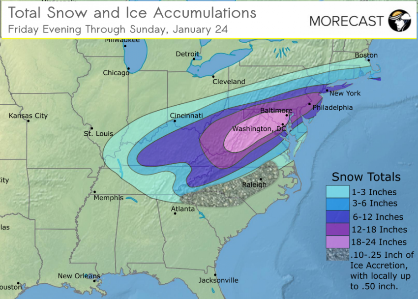
An intense, slow-moving winter storm will move up the Eastern Seaboard Friday evening through Saturday and into early Sunday. The storm will produce heavy snow which will combine with driving winds to create dangerous and prolonged blizzard conditions with near-zero visibilities and massive drifts. Snowfall totals of 8-16 inches will be common with some isolated totals near a foot. Winds will gust 40 to occasionally 55 mph at times, highest along the coast, where some moderate coastal flooding could threaten low-lying areas. Travel will become progressively more difficult through Saturday with some delays and disruptions likely on public transportation lines. Stay safe by avoiding travel and use your MORECAST app to keep up with the latest forecasts.
8:50pm EST Friday New Jersey declares state of emergency
Just In: New Jersey @GovChristie declares state of emergency as powerful winter storm moves into region pic.twitter.com/hgba7kEOPD
— BuzzFeed Storm (@BuzzFeedStorm) January 23, 2016
8:00pm EST Friday NYC buses prepare for the snow
Bus Maintainers at Michael J. Quill Depot chaining up a bus for service during the storm. #BusSnow pic.twitter.com/eIuNj8sBYX
— NYCT Buses (@NYCTBus) January 23, 2016
4:45pm EST Friday NYC Subways plan to operate Saturday
.@MTA is deploying 1,800 personnel to maintain subway operability during the storm. #NYResponds pic.twitter.com/Y2bTM4HfeR
— Andrew Cuomo (@NYGovCuomo) January 22, 2016
1:00pm EST Friday The National Weather Service is launch extra weather balloons to help forecast models
Extra Weather Balloon Launches Continue as a major east coast storm bears down on our area! #Winterstorm pic.twitter.com/OQuHPIdkvI
— NWS New York NY (@NWSNewYorkNY) January 22, 2016
08:30am EST Friday
Before the major storm, a stunning, colorful sunset lights up the sky over lower Manhattan. [@isardasorensen] pic.twitter.com/skIJ4GfTBf
— Good Morning America (@GMA) 22. Januar 2016
Download the weather app MORECAST for free and be prepared for the storm.
