As the days get shorter and the nights grow chillier, and distant mountain peaks gradually turn white, ski bums everywhere are starting to get the urge to strap up and turn their tips downhill! Promising early season snowstorms across western Canada have already given several resorts an alpine snow depth of over 100 cm (39 inches). Big White, at a relatively high altitude compared to other large resorts, opened on 13-November, while Whistler opened on 16-November. Many other resorts are scheduled to open before the end of November.
The early season snows have made organizers of the Audi FIS Alpine World Cup at the Lake Louise Ski Resort in the Canadian Rockies more than pleased. A snowstorm there between 14-16 November dropped 50 cm (20 inches) of fresh powder, enabling a smooth and easy trail preparation process leading up to men’s races scheduled for 25-29 November. Additional snowfall expected for Tuesday 24-November, perhaps up to 20 cm (8 inches) or so, along with temperatures at the resort consistently below or well below 0 deg C (32 deg F) should ensure prime racing conditions. The preliminary forecast for the race days themselves looks perfectly cold and sunny. For the latest pinpoint forecast information covering ski resorts across Canada and the USA, depend on MORECAST!
With the season off to such a great start, it might seem we’re destined for a winter full of abundant snows in western Canada. However, many forecasts for the winter as a whole are suggesting a warmer, drier season than average. The strong El Nino currently dominating weather patterns typically favors a storm track further south, through the American Southwest and the Rockies. The last time the El Nino was this strong was the winter of 1997-98, a winter characterized by below normal seasonal snow totals for many resorts in western Canada, including Whistler, Big White, and Lake Louise. It’s important to acknowledge, though, that for many of these resorts around half the total snowfall in a season comes from only a few big storms. These heavy hitters are notoriously difficult for long-range models to resolve and can certainly help bust a seasonal forecast for below-normal snowfall. If Canadian skiers do end up snow-starved, they might look not only south of the international border with envy but south of the Equator. Huge storms in July and August left snowfall amounts measured in meters (feet) blanketing resorts in the Andes of Chile and Argentina.
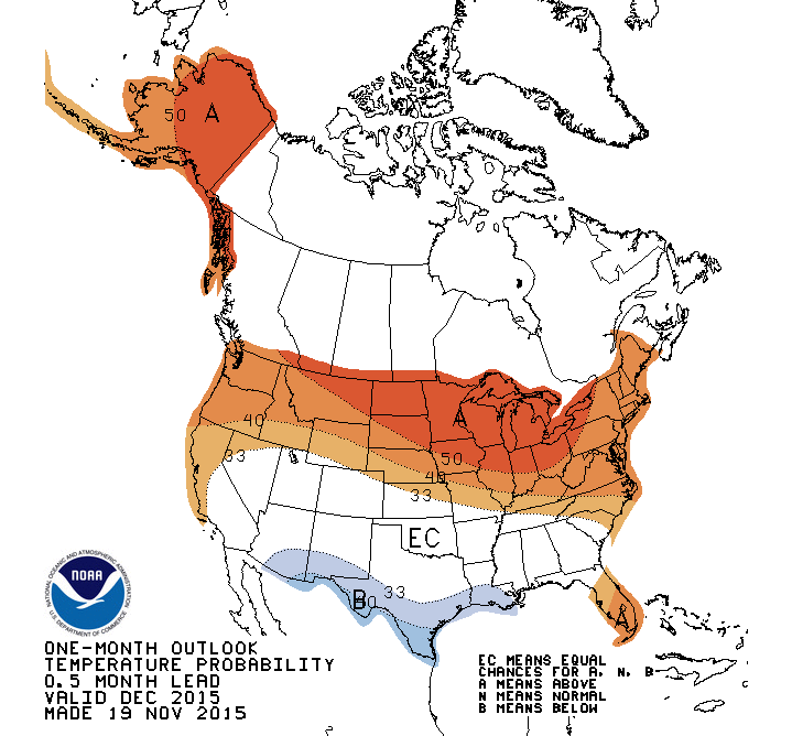
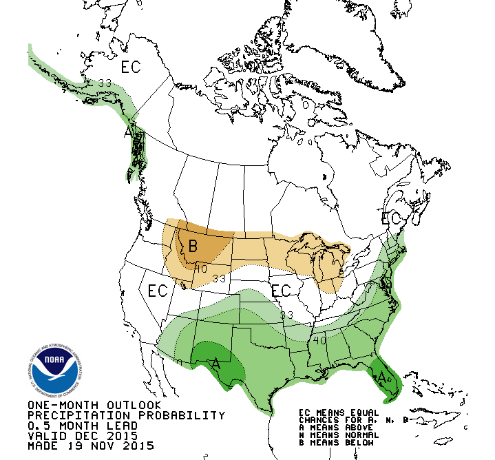
Turning to the prospects for US resorts in the next few weeks, a few solid storms have enabled some resorts to give skiers an early taste of the ski season. The Aspen-Snowmass resort partially opened on 14-November, and is scheduled to open fully on 21-November, five days ahead of schedule. The U.S.Climate Prediction Center’s outlook for the next month (see figures below) would suggest near-normal precipitation and temperatures across many of the resort-dense ranges from Colorado through Utah to California through December. The major resorts in many of these areas saw near to above normal snowfall totals for the winter of 1997-98, the last time the El Nino reached the strength it currently enjoys, however above-normal temperatures associated with strong El Nino events could push snow levels higher than normal, spelling trouble for smaller resorts at marginal elevations.


