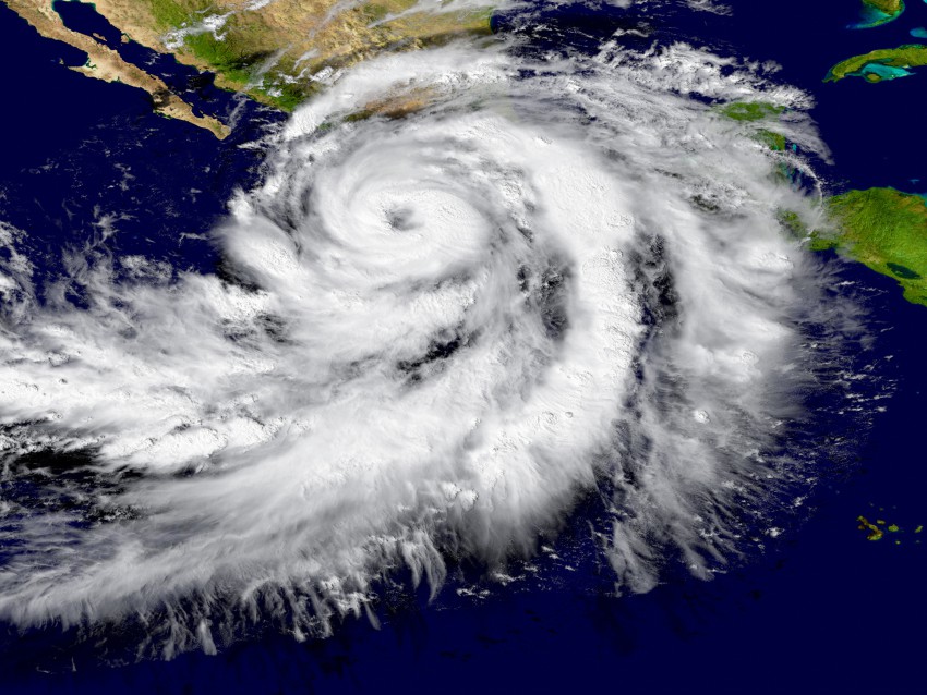
History has taught most of us level-headed meteorologists that the prospects for success in forecasting any given weather event to break (much less shatter) a record are so poor that we usually avoid doing so on principle alone. But even the most excitable among us were staggered by the cycle of intensification experienced by Hurricane Patricia from Thursday into Friday, 22-23rd October, as it turned from just another middling, minimal hurricane skirting by the sparsely-populated coast of southwestern Mexico to a 200-mph monster. That number alone, topping not only the hurricane intensity scale but the higher-threshold Enhanced Fujita tornado intensity scale as well, transformed sober scientists into gawking fanboys eager for a snapshot of history (see figure at right). Patricia shed 100 millibars of surface pressure in 24 hours, the second cyclone ever to accomplish that feat, becoming the strongest storm ever measured in the Western Hemisphere. Only four storms have been able to claim a lower central pressure than Patricia anywhere in the world, all occurring in the uber-fertile Western Pacific tropical basin, including the still-king of the mountain, Typhoon Tip. However, no storm until Patricia could boast of reaching the 200-mph milestone.
Many of the ingredients that helped Patricia rewrite the record books are familiar enough by now to even casual weather watchers. Patricia was moving over ocean waters not only warm but deeply warm at an ideal forward speed, with the typically inhibiting factors of wind shear and proximity to land minimized. Forecasts called for significant strengthening, enough to qualify for the National Hurricane Center’s official threshold for “rapid intensification” of gaining 30 knots (35 mph) of wind speed in 24 hours or less. Rapidly cooling cloud tops as noted on infrared satellite imagery and a bloom of lightning activity in the eyewall suggested that convection was quickly building there, a reliable indicator of an imminent surge of strength. However, many storms enjoy the kind of environment that incubated Patricia without undergoing nearly the same degree of explosive deepening. The means by which Patricia could achieve such a terrifying intensity when other cyclones in the same situation don’t are still insufficiently understood, and are a worthy subject of energetic research.
One fairly unique factor probably working in Patricia’s favor was its small size. Even at peak intensity, wind speeds in excess of 58 mph were limited to an area within 50 miles of Patricia’s center, so that the tremendous amount of energy implied by the historically low central pressure was concentrated over a much smaller area than a storm like, say, Typhoon Tip, whose 58+ mph winds extended almost 175 miles from the center. The well-worn analogy traditionally employed by meteorologists to describe this basic principle of physics (the conservation of angular momentum) involves the figure skater who draws her arms into her body, making herself smaller to speed up her rotation. Ironically that singularly wintry image is probably more familiar to residents of northern climes than folks to the south who are threatened much more often by storms like Patricia.