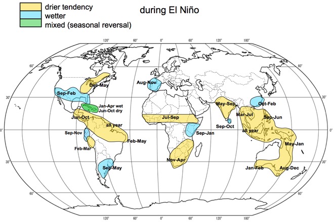
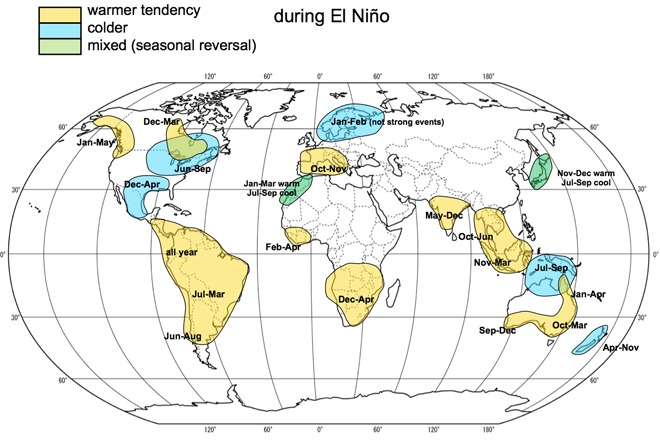
As we head into the second half of summer, a moderate El Nino pattern that began in March is showing signs of strengthening in the Pacific Ocean. And the official forecasts from several different meteorological agencies in the U.S., Australia, Japan and the United Kingdom indicate a high probability that El Nino will last several more months into early 2016. Not only that, but many climate models used by forecasters also indicate this El Nino may end up being one of the strongest on record. As a result, significant changes to weather patterns all over the world are expected.
El Nino refers to persistent above average water temperatures in the eastern equatorial Pacific off the coast of South America. The warmer waters cause wind and pressure patterns in the atmosphere to shift and adjust in strength, leading to changes in the weather. El Nino’s counterpart, when water temperatures drop below average for period of time in eastern Pacific, is known as La Nina. The eastern Pacific tends to alternate between El Nino and La Nina every few years, with neutral phases in between each occurrence. The last El Nino occurred during the winter of 2009/2010.
As of early July, sea surface temperatures in the eastern Pacific were averaging as much as 1.4°C above normal, well above the threshold needed to be considered an El Nino (which is usually 0.5°C to 0.8°C). El Nino’s are usually considered strong when sea surface temperatures are more than 1.5°C above average, so we’re almost to that point.
But what does a strong El Nino mean for Europe? We can look back to past El Nino’s to get an idea of what may be in store in the months ahead. But it is important to remember that the atmosphere is incredibly complex and there are other processes that could enhance or inhibit the impacts from El Nino, so you should view this more as a guide rather than an exact forecast. With that noted, here are possible changes in Europe as we head into the fall and winter months (the impacts of El Nino are fairly minor or non-existent during the summer months):
- Better chance for above average rainfall in western Europe during the autumn, including in Spain, Portugal and and France.
- Better chance for above average temperatures across much of western and southern Europe during the autumn and early winter months, including Portugal, Spain, France, southern Germany, Switzerland, Austria, and Italy.
- Most El Nino’s are correlated to below average wintertime temperatures in Scandinavia and the Baltic States, but the opposite is true for particularly strong El Nino’s (like the one expected this winter), which would favor above average temperatures in northern Europe.


