As we head into the second half of summer, a moderate El Nino pattern that began in March is showing signs of strengthening in the Pacific Ocean. The official forecast from the Climate Prediction Center (CPC) calls for a high probability—an 85% chance—that El Nino will continue into early 2016. Several climate models used by forecasters also indicate this El Nino could end up being one of the strongest on record, which would have major implications in the U.S. as weather patterns change.
El Nino refers to persistent above average water temperatures in the eastern equatorial Pacific off the coast of South America. These warmer waters cause wind patterns in the atmosphere to shift and adjust in strength, leading to changes in our weather.
In the U.S., an El Nino is considered to be ongoing when sea surface temperatures in the eastern Pacific are at least 0.5°C above average for three consecutive months, along with associated changes to wind patterns and thunderstorm activity across the western and central Pacific Ocean. As of early July, sea surface temperatures in the eastern Pacific were averaging between 1.0 and 1.4°C above normal, and the expected circulation patterns in the atmosphere during El Nino events were being observed. El Nino’s are generally considered strong when the SST anomaly tops 1.5°C, so we’re not too far away from being able to call this a strong El Nino.
Generally speaking, El Nino’s don’t cause dramatic changes to the weather pattern in the U.S. during the summer months. The only notable exception to this is in the tropics, where upper level wind patterns influenced by El Nino make it harder for tropical storms and hurricanes to form, decreasing the number storms that develop in the Atlantic Ocean, Gulf of Mexico and Caribbean Sea compared to average. But that doesn’t mean people and businesses with interests on the eastern shore and Gulf coast should let their guard down during El Nino years. Even if there are fewer storms, it only takes one to cause mayhem, so it’s important to keep tabs on the short-term forecast.
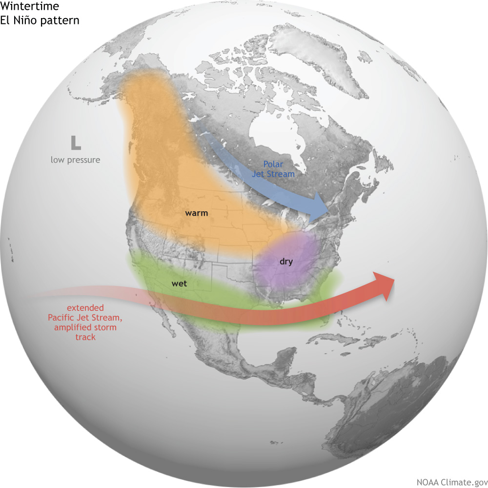
The winter months are where El Nino’s impacts are felt the strongest across much of the United States. The changes include:
- Below average temperatures but above average rainfall and severe weather outbreaks in the southeastern United States
- Above average temperatures across much of the northern U.S., from the Great Lakes to the Pacific Northwest.
- Below average precip (i.e. less snow) in the Great Lakes and Ohio Valley.
- Above average rainfall in the desert southwest and, of particular note, in California.
It will be interesting to see if this winter will provide relief to the historic drought ongoing in California. The last strong El Nino in 1997-98 brought record rainfalls to parts of the state, and some models have this winter’s El Nino coming in just as strong. While the rain is badly needed out west, a large amount of precipitation this winter would increase the risk for mudslides, especially in areas impacted in recent years by large wildfires.
Wrap Up
We’ve seen the general impacts El Nino can have on the weather patterns in the U.S., but it should be noted that other factors not associated with El Nino may enhance or diminish these impacts. But past El Nino events do provide an overall guide to forecasters on what may be in store in the months ahead as El Nino continues in the eastern Pacific Ocean.

