Forecasting the strongest winds in North Atlantic winter storms is always a difficult task, however there is one particularly dangerous phenomenon associated with some of the most destructive systems. Sting jets can produce winds in excess of 100 mph (160 kph), across a limited area – only up to 50 miles (80km). Several famous storms have been associated with sting jets, including Cyclone Ulli in 2011 (Scotland), and the Great Storm of 1987 (southern England).
What is a Sting Jet?
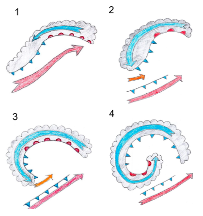
In a storm where a sting jet occurs, it will be positioned in the area of the storm at the “cloud head”, found at the tip of the comma shape of clouds in the center of a windstorm. The sketches below show the four stages of a sting jet, from formation to dissipation. As the storm intensifies (1), two areas of strong wind (jets) will be present at roughly three km above the surface: a jet from the south on the eastern side of the storm, and a jet from the north on the western side of the storm. As the storm reaches its strongest phase, the jet from the north will force the cold front to the south of the low pressure to break apart, otherwise known as a “fracture” (2). At this point, the winds from the north exit the cloud head into dry air. As snow and rain is driven into the drier air, it evaporates (3). The evaporation process draws heat energy from the air, and so with evaporation, the temperature of the air cools. Since cool air sinks, the jet will descend towards the surface. The sharp looking point to the cloud head at this time gives rise to the name “sting jet”, now occurring in the storm. The winds that reach the surface can cause damage across a narrow area, no more than fifty miles wide at a time, over the course of two to four hours. The strongest winds are also sporadic, gusty, and as such very difficult to precisely warn for. After those two to four hours few hours the sting jet will weaken and dissipate (4).
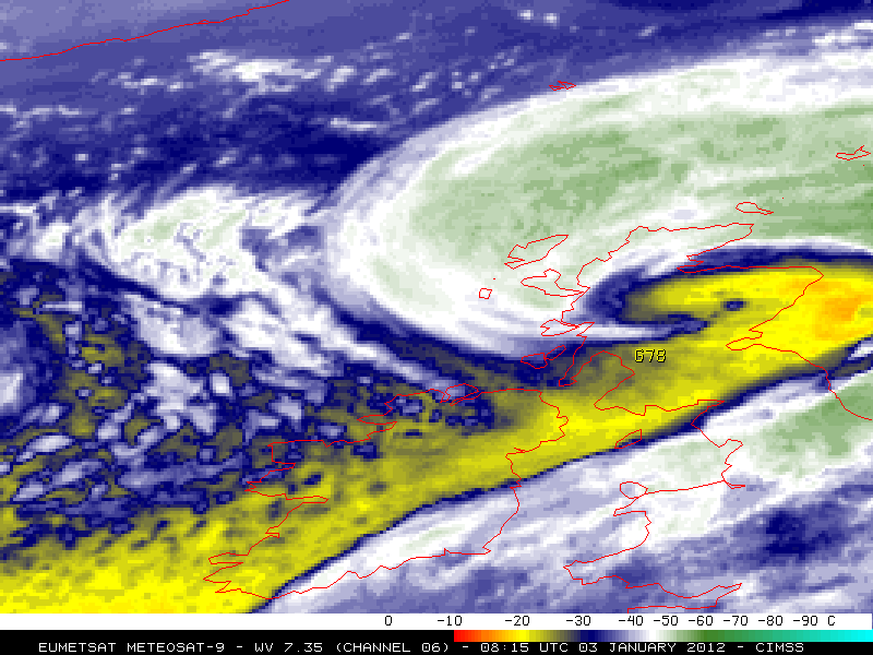
The satellite image (of Cyclone “Ulli”, 2012) below shows the namesake “sting” to the cloud head at the tip of the comma shape mentioned earlier.
Where do sting jets occur?
Overwhelmingly, sting jets will be associated with winter extratropical storms in the North Atlantic. On a small number of occasions, sting jets have been proposed to have formed in particularly strong winter storms over North America and the North American Atlantic coast. Given the British Isles’ exposure to westerly atmospheric flow over the Atlantic, the UK and Ireland bear the brunt of sting jet damage. Owing to this, the UK Met Office and leading British universities are the global research leaders on the phenomenon.
What are some well-known examples of sting jets?
Perhaps the most infamous example is the Great Storm of 1987 that affected the south coast of England. The strongest recorded wind speed was 134 mph (216 kph), and the storm resulted in 22 fatalities. Other more recent examples include Windstorms Friedhelm and Ulli that affected Central Scotland in 2011 and 2012.


